WMS:GSSHA Feature Polygons: Difference between revisions
No edit summary |
No edit summary |
||
| Line 1: | Line 1: | ||
[[Image:GSSHA Lakes and Wetlands.jpg|thumb|400 px]] | |||
A new feature of GSSHA 2.0 is the ability to simulate lakes and wetland areas. By attenuating and storing the incoming flow, lakes and wetlands prove to be important hydrologic features of a basin and dramatically alter the response of a watershed to a precipitation event. Both in-stream and out-of-stream lakes and wetland areas can be simulated. Lakes and wetlands are conceptually modeled in WMS as polygons in the GSSHA coverage. | A new feature of GSSHA 2.0 is the ability to simulate lakes and wetland areas. By attenuating and storing the incoming flow, lakes and wetlands prove to be important hydrologic features of a basin and dramatically alter the response of a watershed to a precipitation event. Both in-stream and out-of-stream lakes and wetland areas can be simulated. Lakes and wetlands are conceptually modeled in WMS as polygons in the GSSHA coverage. | ||
===GSSHA Polygon Type=== | ===GSSHA Polygon Type=== | ||
| Line 18: | Line 15: | ||
Wetland polygons define the cells that form part of a wetland. Five parameters must be specified for each wetlands area, retention depth, hydraulic conductivity, retention depth hydraulic conductivity, maximum storage depth, and the base elevation | Wetland polygons define the cells that form part of a wetland. Five parameters must be specified for each wetlands area, retention depth, hydraulic conductivity, retention depth hydraulic conductivity, maximum storage depth, and the base elevation | ||
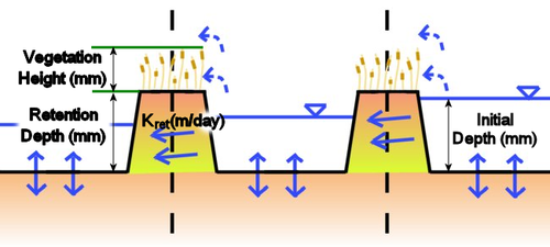
[[Image:wetlands1.png| | [[Image:wetlands1.png|thumb|none|left|500 px|'''Figure 27.''' Lateral seepage flow conceptually is the flow through the subsurface peat layer. It is calculated as a darcian flow across the entire cell face. The flow through the vegetation is computed as a mixed mode flow, darcian and manning's. The flow is computed for both darcian and manning's flow and the actual flow rate varies between the two depending on the water height in relation to the plant height.]] | ||
====Depression Mask==== | ====Depression Mask==== | ||
Revision as of 21:44, 21 February 2013
A new feature of GSSHA 2.0 is the ability to simulate lakes and wetland areas. By attenuating and storing the incoming flow, lakes and wetlands prove to be important hydrologic features of a basin and dramatically alter the response of a watershed to a precipitation event. Both in-stream and out-of-stream lakes and wetland areas can be simulated. Lakes and wetlands are conceptually modeled in WMS as polygons in the GSSHA coverage.
GSSHA Polygon Type
Generic
Generic polygons have no attributes.
Boundary
Boundary polygons are used to define the perimeter of the watershed and are used for creating grids from an already known watershed boundary.
Lake
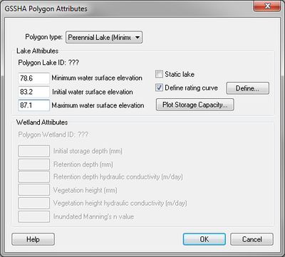
Lake polygons are used to define cells within a grid used to simulate lakes during a GSSHA simulation. Initial leakage discharge, spillway crest width, discharge coefficient, initial water elevation and crest elevation must be defined for each lake.
Wetland
Wetland polygons define the cells that form part of a wetland. Five parameters must be specified for each wetlands area, retention depth, hydraulic conductivity, retention depth hydraulic conductivity, maximum storage depth, and the base elevation

Depression Mask
Depression mask polygons mask cells contained within the polygon. The elevations of the cells located inside a depression mask polygon are not altered when the CleanDam program is run from WMS.
Related Topics:
GSSHA | |
|---|---|
| XMS Wiki Links | Calibration (Automated • Manual • Output) • Channel Routing • Contaminants • Digital Dams • Embankment Arcs • Feature Objects (Arcs • Nodes • Polygons) • File Types • Groundwater • Groups • Hydraulic Structures • Job Control • Join SSURGO Data • Mapping Tables • Maps • Menu • Model Linkage • Multiple Simulations • Nutrients • Observations • Output Control • Overland Soil Erosion • Pipe and Node Parameters • Precipitation • Radar Rainfall • Save GSSHA Project File • Smooth GSSHA Streams • Snowmelt • Solution (Analysis • Data) |
| Related Tools | MWBM Wizard • Using Soil Type Data with GSSHA |
| GSSHA Wiki External Links | GSSHA Wiki: Overview • Primer • User's Manual • Tutorials |
