WMS:GSSHA Calibration Output
From XMS Wiki
Jump to navigationJump to search

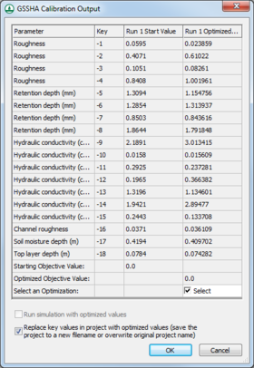
The GSSHA Calibration Output dialog can appear after a GSSHA run.
The parameter list spreadsheet has a row for each key value, showing the following information for each entry:
- Parameter – Displays the name of the parameter and the units used by the parameter (if any).
- Key – The key value ID associated with the parameter.
- Run 1 Start Value – The initial value for the parameter at the beginning of the first run.
- Run 1 Optimized Value – The optimized value after the first run.
Additional run columns will appear with multiple runs.
At the bottom of the spreadsheet are entries for the following:
- Starting Objective Value – The objective value before a specific run.
- Optimized Objective Value – The optimized objective value obtained after a specific run.
At the bottom of each optimized run is a checkbox:
- Select an Optimization – Turn on the checkbox to select that optimized run for importing into the project.
At the bottom of the dialog are the following options:
- Run simulation with optimized values – Turn on to run the simulation using the selected optimized values.
- Replace key values in project with optimized values – Turn on to replace the original key values in the project with the optimized key values. If this option is turned on, a Save GSSHA Project FIle dialog will appear when OK is clicked, allowing the original project to be overwritten, or allowing a new project to be saved under a new name.
- OK – Save all changes and close the GSSHA Calibration Output dialog.
- Cancel – Discard all changes and close the GSSHA Calibration Output dialog.
GSSHA | |
|---|---|
| XMS Wiki Links | Calibration (Automated • Manual • Output) • Channel Routing • Contaminants • Digital Dams • Embankment Arcs • Feature Objects (Arcs • Nodes • Polygons) • File Types • Groundwater • Groups • Hydraulic Structures • Job Control • Join SSURGO Data • Mapping Tables • Maps • Menu • Model Linkage • Multiple Simulations • Nutrients • Observations • Output Control • Overland Soil Erosion • Pipe and Node Parameters • Precipitation • Radar Rainfall • Save GSSHA Project File • Smooth GSSHA Streams • Snowmelt • Solution (Analysis • Data) |
| Related Tools | MWBM Wizard • Using Soil Type Data with GSSHA |
| GSSHA Wiki External Links | GSSHA Wiki: Overview • Primer • User's Manual • Tutorials |
WMS – Watershed Modeling System | ||
|---|---|---|
| Modules: | Terrain Data • Drainage • Map • Hydrologic Modeling • River • GIS • 2D Grid • 2D Scatter |  |
| Models: | CE-QUAL-W2 • GSSHA • HEC-1 • HEC-HMS • HEC-RAS • HSPF • MODRAT • NSS • OC Hydrograph • OC Rational • Rational • River Tools • Storm Drain • SMPDBK • SWMM • TR-20 • TR-55 | |
| Toolbars: | Modules • Macros • Units • Digitize • Static Tools • Dynamic Tools • Drawing • Get Data Tools | |
| Aquaveo | ||