WMS:GSSHA Mapping Tables: Difference between revisions
No edit summary |
|||
| Line 17: | Line 17: | ||
[[Category:GSSHA|M]] | [[Category:GSSHA|M]] | ||
[[Category:WMS Dialogs|G]] | |||
Revision as of 21:08, 3 March 2014
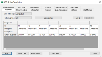
The mapping tables are where all of the spatially distributed parameters for all of the options specified in the Job Control are inputted. The mapping tables relate parameter sets for each process to an index map that shows their spatial distribution.
The several processes available for a GSSHA simulation are shown in the Process window. Once a process is chosen, an index map may be assigned to it in the drop-down box below the Process window. The Generate IDs From Map button takes the assigned index map and creates a list of IDs, shown in the ID window, that are used in the index map. Once the IDs have been generated one may be selected and its properties edited by selecting the property in the Property Table and editing the value or string in the edit field below the Property Table. The individual ID parameters may be edited as well as the descriptive text that was automatically generated by WMS.
If a process is selected in the Process window, and the Job Control option for that process is not turned on, WMS will ask if you would like to turn on that process in the Job Control and will bring up the Job Control dialog for you to do so. If an index map has been assigned to a process and the IDs used in the index map increases then you will need to generate IDs from the index map again and re-input the parameters for each ID for that map.
Related Topics:
GSSHA | |
|---|---|
| XMS Wiki Links | Calibration (Automated • Manual • Output) • Channel Routing • Contaminants • Digital Dams • Embankment Arcs • Feature Objects (Arcs • Nodes • Polygons) • File Types • Groundwater • Groups • Hydraulic Structures • Job Control • Join SSURGO Data • Mapping Tables • Maps • Menu • Model Linkage • Multiple Simulations • Nutrients • Observations • Output Control • Overland Soil Erosion • Pipe and Node Parameters • Precipitation • Radar Rainfall • Save GSSHA Project File • Smooth GSSHA Streams • Snowmelt • Solution (Analysis • Data) |
| Related Tools | MWBM Wizard • Using Soil Type Data with GSSHA |
| GSSHA Wiki External Links | GSSHA Wiki: Overview • Primer • User's Manual • Tutorials |
