GMS:STR/SFR Packages: Difference between revisions
From XMS Wiki
Jump to navigationJump to search
| Line 75: | Line 75: | ||
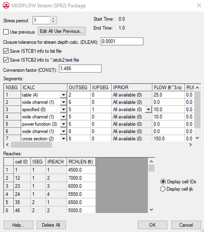
Once the '''Map → MODFLOW''' command is selected and the stream data have been assigned to the grid cells, the data can be viewed and some of the input values can be edited using the ''MODFLOW Stream (SFR2) Package'' dialog. Stream segments and reaches cannot be created in the ''MODFLOW Stream (SFR2) Package'' dialog—creation can only be done via the '''Map → MODFLOW''' command. The ''MODFLOW Stream (SFR2) Package'' dialog has two spreadsheets, one showing stream segments and one showing stream reaches. For a further explanation of the columns in each spreadsheet, refer to the [http://water.usgs.gov/nrp/gwsoftware/modflow2000/MFDOC/sfr.htm Online Guide to MODFLOW]. Note: GMS does not currently support the optional parameters ISFROPT, NSTRAIL, ISUZN, and NSFRSETS which are all defaulted to zero by GMS. | Once the '''Map → MODFLOW''' command is selected and the stream data have been assigned to the grid cells, the data can be viewed and some of the input values can be edited using the ''MODFLOW Stream (SFR2) Package'' dialog. Stream segments and reaches cannot be created in the ''MODFLOW Stream (SFR2) Package'' dialog—creation can only be done via the '''Map → MODFLOW''' command. The ''MODFLOW Stream (SFR2) Package'' dialog has two spreadsheets, one showing stream segments and one showing stream reaches. For a further explanation of the columns in each spreadsheet, refer to the [http://water.usgs.gov/nrp/gwsoftware/modflow2000/MFDOC/sfr.htm Online Guide to MODFLOW]. Note: GMS does not currently support the optional parameters ISFROPT, NSTRAIL, ISUZN, and NSFRSETS which are all defaulted to zero by GMS. | ||
====ISTCB2 | ====ISTCB2 Info==== | ||
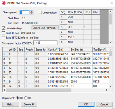
If the ''Save ISTCB2 info to *.istcb2 text file'' option is on, MODFLOW will save more stream related data to a text file which has the same prefix as the other MODFLOW files and a "*.istcb2" extension. This text file will be displayed in the MODFLOW Solution in the [[GMS:Project Explorer|Project Explorer]] when the solution is imported. The data in this file includes information on "inflows and outflows from each reach; on stream depth, width, and streambed conductance; and on head difference and gradient across the streambed." | If the ''Save ISTCB2 info to *.istcb2 text file'' option is on, MODFLOW will save more stream related data to a text file which has the same prefix as the other MODFLOW files and a "*.istcb2" extension. This text file will be displayed in the MODFLOW Solution in the [[GMS:Project Explorer|Project Explorer]] when the solution is imported. The data in this file includes information on "inflows and outflows from each reach; on stream depth, width, and streambed conductance; and on head difference and gradient across the streambed." | ||
| Line 82: | Line 82: | ||
Starting at GMS 9.0, this information is saved to a second CCF file that will appear in the solution as "CCF2". This is so that the stream flow out of each reach is not included in the flows in and out of the aquifer in the [[GMS:Zone_Budget|flow budget]]. The total stream flow out of each reach is displayed at the bottom of the flow budget. | Starting at GMS 9.0, this information is saved to a second CCF file that will appear in the solution as "CCF2". This is so that the stream flow out of each reach is not included in the flows in and out of the aquifer in the [[GMS:Zone_Budget|flow budget]]. The total stream flow out of each reach is displayed at the bottom of the flow budget. | ||
===== STREAMFLOW_OUT | ===== STREAMFLOW_OUT Dataset ===== | ||
The stream flow out of each reach is stored in the ccf file under the heading STREAMFLOW_OUT. GMS can convert data in the CCF file to 3D grid datasets that can be contoured by right-clicking on the CCF file in the Project Explorer and using the ''CCF → Datasets'' command. If in the ccf file multiple flows are listed for the same cell, GMS sums them so that there is only one value for each cell in the resulting dataset. With most data this makes sense because the data represents the total flow into our out of the aquifer due to the BC (wells, river etc). The STREAMFLOW_OUT data is treated the same way, but in this case it doesn't make sense to sum the values because they don't represent flow to or from the aquifer. The problem becomes evident wherever there is more than one stream reach in a cell, which happens wherever a stream segment begins/ends in a cell. The STREAMFLOW_OUT dataset value will be the sum of all the reaches in the cell, which can make it appear as if much more water is flowing down the stream than there should be in that cell. If using SFR2, the user should save the istcb2 data as a text file (described above) which lists the streamflow out of each segment and reach separately. Despite this problem, the STREAMFLOW_OUT dataset can still be useful for contouring and display purposes. | The stream flow out of each reach is stored in the ccf file under the heading STREAMFLOW_OUT. GMS can convert data in the CCF file to 3D grid datasets that can be contoured by right-clicking on the CCF file in the Project Explorer and using the ''CCF → Datasets'' command. If in the ccf file multiple flows are listed for the same cell, GMS sums them so that there is only one value for each cell in the resulting dataset. With most data this makes sense because the data represents the total flow into our out of the aquifer due to the BC (wells, river etc). The STREAMFLOW_OUT data is treated the same way, but in this case it doesn't make sense to sum the values because they don't represent flow to or from the aquifer. The problem becomes evident wherever there is more than one stream reach in a cell, which happens wherever a stream segment begins/ends in a cell. The STREAMFLOW_OUT dataset value will be the sum of all the reaches in the cell, which can make it appear as if much more water is flowing down the stream than there should be in that cell. If using SFR2, the user should save the istcb2 data as a text file (described above) which lists the streamflow out of each segment and reach separately. Despite this problem, the STREAMFLOW_OUT dataset can still be useful for contouring and display purposes. | ||


