WMS:GSSHA Nutrients: Difference between revisions
From XMS Wiki
Jump to navigationJump to search
No edit summary |
No edit summary |
||
| Line 23: | Line 23: | ||
#*Groundwater other initial conditions | #*Groundwater other initial conditions | ||
#Turn on any nutrient related output options in the ''Output Control'' dialog to view your desired datasets. | #Turn on any nutrient related output options in the ''Output Control'' dialog to view your desired datasets. | ||
#If you want to define Point Sources or Non-Point Sources, select the ''Nutrients'' button in the '''GSSHA Job Control''' dialog. If defining non-point sources, you need to define a grid-based or a stream-based index map associated with the non-point source. If defining a point source, you need to determine the I, J index of the cell if defining an overland point source or the Link, Node index if defining a stream point source. | #If you want to define Point Sources or Non-Point Sources, select the ''Nutrients'' button in the '''GSSHA Job Control''' dialog. If defining non-point sources, you need to define a grid-based or a stream-based index map associated with the non-point source. If defining a point source, you need to determine the I, J index of the cell if defining an overland point source or the Link, Node index if defining a stream point source. Whether defining a point or non-point contaminant source, you need to define a mass curve or a concentration curve for any contaminant source you want to model. | ||
Other important troubleshooting notes: | Other important troubleshooting notes: | ||
Revision as of 20:44, 18 March 2013
To model nutrients using GSSHA:
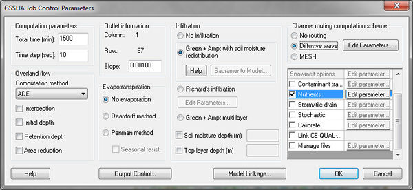
- Toggle on the Nutrients option in the Job Control.
- Open the Nutrients dialog to view the four nutrient tabs: Point Sources, Non Point Sources, Other, and Uniform Properties. Enter nutrient concentrations in the Other tab. These concentrations will be applied to rainfall input. The Uniform properties tab contains default values for uniform nutrient properties. You may adjust these values as you see fit.
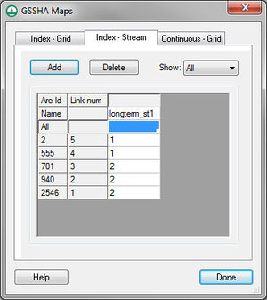
- Create stream and grid index maps. At least one stream and one grid index map is required for nutrient setup.
- Set up the initial conditions for the stream and grid index maps using the Nutrients map tables in the GSSHA Map Table dialog. The following map tables are supported:
- Aquatic kinetic constants
- Dispersion
- Nitrogen initial conditions
- Phosphorus initial conditions
- Carbon initial conditions
- Other initial conditions
- Soil nitrogen initial conditions
- Soil phosphorus initial conditions
- Soil carbon initial conditions
- Soil uptake rates
- Soil/water partitioning
- Groundwater nitrogen initial conditions
- Groundwater phosphorus initial conditions
- Groundwater other initial conditions
- Turn on any nutrient related output options in the Output Control dialog to view your desired datasets.
- If you want to define Point Sources or Non-Point Sources, select the Nutrients button in the GSSHA Job Control dialog. If defining non-point sources, you need to define a grid-based or a stream-based index map associated with the non-point source. If defining a point source, you need to determine the I, J index of the cell if defining an overland point source or the Link, Node index if defining a stream point source. Whether defining a point or non-point contaminant source, you need to define a mass curve or a concentration curve for any contaminant source you want to model.
Other important troubleshooting notes:
- GSSHA nutrients can only be modeled in long-term simulations
- The contaminants option must be turned on with at least one contaminant in order for nutrients to run. In this case, all contaminant parameters can be left at 0.
- You must turn on the initial depth option in the job control and specify an initial depth for any initial condition nutrient mapping tables to have any effect
- You must have at least one ID for all nutrient mapping tables for nutrients to run properly, even if the values for some IDs are all 0.
Related Topics
GSSHA | |
|---|---|
| XMS Wiki Links | Calibration (Automated • Manual • Output) • Channel Routing • Contaminants • Digital Dams • Embankment Arcs • Feature Objects (Arcs • Nodes • Polygons) • File Types • Groundwater • Groups • Hydraulic Structures • Job Control • Join SSURGO Data • Mapping Tables • Maps • Menu • Model Linkage • Multiple Simulations • Nutrients • Observations • Output Control • Overland Soil Erosion • Pipe and Node Parameters • Precipitation • Radar Rainfall • Save GSSHA Project File • Smooth GSSHA Streams • Snowmelt • Solution (Analysis • Data) |
| Related Tools | MWBM Wizard • Using Soil Type Data with GSSHA |
| GSSHA Wiki External Links | GSSHA Wiki: Overview • Primer • User's Manual • Tutorials |

