GMS:DRN Package: Difference between revisions
From XMS Wiki
Jump to navigationJump to search
No edit summary |
|||
| Line 2: | Line 2: | ||
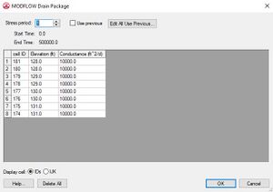
The Drain package is used to simulate the effect of drains on an aquifer. Drains remove water from the aquifer as long as the water table is above the elevation of the drain. If the water table falls below the elevation of the drain, the drain has no effect. The rate of removal is proportional to the difference in elevation between the water table and the drain. The constant of proportionality is the conductance of the fill material surrounding the drain. | The Drain package is used to simulate the effect of drains on an aquifer. Drains remove water from the aquifer as long as the water table is above the elevation of the drain. If the water table falls below the elevation of the drain, the drain has no effect. The rate of removal is proportional to the difference in elevation between the water table and the drain. The constant of proportionality is the conductance of the fill material surrounding the drain. | ||
A set of selected cells can be specified as drains using the '''Point Sources/Sinks''' command in the MODFLOW menu or drains can be defined using the [[GMS:MODFLOW Conceptual Model Approach|conceptual model]] approach in the map module. Drains are specified by assigning an elevation and a conductance to each cell at the location of each drain. | A set of selected cells can be specified as drains using the '''Point Sources/Sinks''' command in the ''MODFLOW'' menu or drains can be defined using the [[GMS:MODFLOW Conceptual Model Approach|conceptual model]] approach in the map module. Drains are specified by assigning an elevation and a conductance to each cell at the location of each drain. | ||
The drain attribute may be associated with points, arcs, or polygons. There are two parameters that are associated with a drain: elevation and conductance. Elevation may be specified as a constant value or transient series, or interpolated from an existing TIN. Conductance may be constant or vary with time. | The drain attribute may be associated with points, arcs, or polygons. There are two parameters that are associated with a drain: elevation and conductance. Elevation may be specified as a constant value or transient series, or interpolated from an existing TIN. Conductance may be constant or vary with time. | ||
