WMS:Project Explorer Contents for Map Module: Difference between revisions
No edit summary |
No edit summary |
||
| Line 27: | Line 27: | ||
*'''Remove Orphaned Nodes''': | *'''Remove Orphaned Nodes''': | ||
*''Type'': | *''Type'': | ||
**'''See coverage types [[WMS:Coverages #Coverage Types|here]]''' | |||
*''Projection'': | *''Projection'': | ||
*'''Save As''': Used to designate the path and prefix file name for saving a coverage . | **'''Projection''' | ||
**'''Set as Display Projection''' | |||
**'''Reproject''' | |||
**'''Transform''' | |||
*'''Save As''': Used to designate the path and prefix file name for saving a coverage. | |||
*'''Properties''':Brings up the Properties window for the coverage. | *'''Properties''':Brings up the Properties window for the coverage. | ||
*'''Display Options''':Brings up the Display Options dialog. | *'''Display Options''':Brings up the Display Options dialog. | ||
Revision as of 20:52, 13 December 2019
In the Map module the coverages and images are listed in the Project Explorer. At this point CAD data are not supported in the Project Explorer, but it is anticipated that in future versions the CAD data will also be controlled from the Project Explorer.
A toggle is next to each object; the toggle controls the visibility. The display is automatically updated when the toggle is checked or unchecked. The active coverage is set in the Project Explorer by selecting it. The active coverage is indicated in the Project Explorer display with a color map module icon, while the inactive coverages are gray.
Right-clicking on the Map Data folder ![]() allows creating a New coverage or New folder for organizing coverages.
allows creating a New coverage or New folder for organizing coverages.
The Project Explorer replaces the Coverage Options dialog in previous versions of WMS. See Coverages to learn about coverages in the Project Explorer.
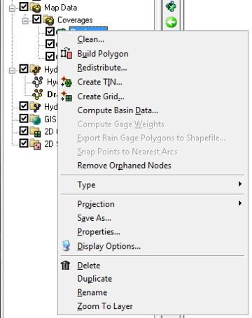
Right-clicking on a coverage ![]() brings up a menu with options to Delete, Duplicate, Rename, set/view the Properties of the coverage, or perform a Coordinate Conversion. Properties include the name and coverage type.
brings up a menu with options to Delete, Duplicate, Rename, set/view the Properties of the coverage, or perform a Coordinate Conversion. Properties include the name and coverage type.
- Clean:
- Build Polygon:
- Redistribute:
- Create TIN:
- Create Grid:
- Compute Basin Data:
- Compute Gage Weights:
- Export Rain Gage Polygons to Shapefile:
- Snap Points to Nearest Arcs:
- Remove Orphaned Nodes:
- Type:
- See coverage types here
- Projection:
- Projection
- Set as Display Projection
- Reproject
- Transform
- Save As: Used to designate the path and prefix file name for saving a coverage.
- Properties:Brings up the Properties window for the coverage.
- Display Options:Brings up the Display Options dialog.
- Delete: Removes the coverage from the project.
- Duplicate: Creates a copy of the coverage.
- Rename: Lets the name of the coverage be changed in the Project Explorer.
- Zoom To Layer: Will resize the coverage data so it fills the Graphics Window.
Related Topics
WMS – Watershed Modeling System | ||
|---|---|---|
| Modules: | Terrain Data • Drainage • Map • Hydrologic Modeling • River • GIS • 2D Grid • 2D Scatter |  |
| Models: | CE-QUAL-W2 • GSSHA • HEC-1 • HEC-HMS • HEC-RAS • HSPF • MODRAT • NSS • OC Hydrograph • OC Rational • Rational • River Tools • Storm Drain • SMPDBK • SWMM • TR-20 • TR-55 | |
| Toolbars: | Modules • Macros • Units • Digitize • Static Tools • Dynamic Tools • Drawing • Get Data Tools | |
| Aquaveo | ||


