GMS:MNW2 Package: Difference between revisions
From XMS Wiki
Jump to navigationJump to search
(Created page with "{{Version GMS 8.3}} {{MODFLOW Links}} The Multi-Node Well (MNW2) package is an updated revision MNW package meant to replace the MNW1 Package. It includes m...") |
No edit summary |
||
| Line 5: | Line 5: | ||
MNW2 boundary conditions can be directly added via the Multi-Node well (MNW2) package dialog. Boundary conditions can also be added to selected cells using the Point Sources/Sinks command in the MODFLOW menu. For a [[GMS:MODFLOW Conceptual Model Approach|conceptual model]] MNW2 points can be defined in the [[GMS:Map Module|map module]]. | MNW2 boundary conditions can be directly added via the Multi-Node well (MNW2) package dialog. Boundary conditions can also be added to selected cells using the Point Sources/Sinks command in the MODFLOW menu. For a [[GMS:MODFLOW Conceptual Model Approach|conceptual model]] MNW2 points can be defined in the [[GMS:Map Module|map module]]. | ||
{{hide in print| | |||
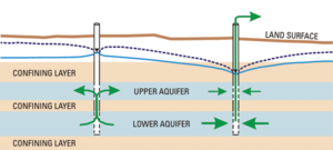
[[Image:mnw2.png|thumb|none|300px|Illustration of MNW2 package<ref name="ofr00-466">{{citation | |||
|last=Konikow | |||
|first=Leonard F. | |||
|title=Revised multi-node well (MNW2) package for MODFLOW ground-water flow model: U.S. Geological Survey Techniques and Methods 6–A30 | |||
|place=Reston, Virginia | |||
|year=2009 | |||
|url=http://pubs.usgs.gov/tm/tm6a30/pdf/TM-6A30__hirez.pdf | |||
}}</ref>]]}} | |||
{{only in print| | |||
[[Image:mnw2.png|thumb|none|250px|Illustration of MNW2 package<ref name="ofr00-466">{{citation | |||
|last=Konikow | |||
|first=Leonard F. | |||
|title=Revised multi-node well (MNW2) package for MODFLOW ground-water flow model: U.S. Geological Survey Techniques and Methods 6–A30 | |||
|place=Reston, Virginia | |||
|year=2009 | |||
|url=http://pubs.usgs.gov/tm/tm6a30/pdf/TM-6A30__hirez.pdf | |||
}}</ref>]]}} | |||
==Notes== | |||
<references/> | |||
{{Navbox GMS}} | {{Navbox GMS}} | ||
[[Category:MODFLOW]] | [[Category:MODFLOW]] | ||
Revision as of 00:04, 18 January 2012
| This contains information about functionality available at GMS version 8.3. The content may not apply to other versions. |
Notes
- ^ Konikow, Leonard F. (2009), Revised multi-node well (MNW2) package for MODFLOW ground-water flow model: U.S. Geological Survey Techniques and Methods 6–A30, Reston, Virginia, http://pubs.usgs.gov/tm/tm6a30/pdf/TM-6A30__hirez.pdf
GMS – Groundwater Modeling System | ||
|---|---|---|
| Modules: | 2D Grid • 2D Mesh • 2D Scatter Point • 3D Grid • 3D Mesh • 3D Scatter Point • Boreholes • GIS • Map • Solid • TINs • UGrids | |
| Models: | FEFLOW • FEMWATER • HydroGeoSphere • MODAEM • MODFLOW • MODPATH • mod-PATH3DU • MT3DMS • MT3D-USGS • PEST • PHT3D • RT3D • SEAM3D • SEAWAT • SEEP2D • T-PROGS • ZONEBUDGET | |
| Aquaveo | ||
