WMS:Project Explorer Contents for River Module
The Project Explorer contents for the river module include hydraulic schematics, cross sections, reaches, links, and nodes. Cross sections and reaches are used with HEC-RAS and SMPBDK models. Links and nodes are used in SWMM models.
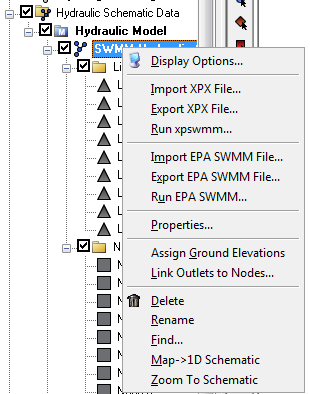
Right-clicking on a hydraulic schematic ![]() gives several options. The available options changes depending on the type of model being used. For example, right-clicking on a SWMM schematic brings up the following menu:
gives several options. The available options changes depending on the type of model being used. For example, right-clicking on a SWMM schematic brings up the following menu:
Right-clicking on cross sections ![]() , reaches, links
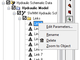
, reaches, links ![]() , or nodes either from the Project Explorer window or from the Graphics Window brings up a menu similar to the following:
, or nodes either from the Project Explorer window or from the Graphics Window brings up a menu similar to the following:
If making a change to the map data (arcs) used to generate the hydraulic schematic, just re-generate the schematic from the by right-clicking on the hydraulic schematic and selecting the Map→1D Schematic menu item.
WMS – Watershed Modeling System | ||
|---|---|---|
| Modules: | Terrain Data • Drainage • Map • Hydrologic Modeling • River • GIS • 2D Grid • 2D Scatter |  |
| Models: | CE-QUAL-W2 • GSSHA • HEC-1 • HEC-HMS • HEC-RAS • HSPF • MODRAT • NSS • OC Hydrograph • OC Rational • Rational • River Tools • Storm Drain • SMPDBK • SWMM • TR-20 • TR-55 | |
| Toolbars: | Modules • Macros • Units • Digitize • Static Tools • Dynamic Tools • Drawing • Get Data Tools | |
| Aquaveo | ||

