GMS:SWI Package
From XMS Wiki
| This contains information about a future release of GMS. The content may not apply to other versions. |
| MODFLOW | |
|---|---|
| Pre-processing | |
| MODFLOW Commands | |
| Building a MODFLOW Model | |
| Map to MODFLOW | |
| Calibration | |
| Packages Supported in GMS | |
| Saving a MODFLOW Simulation | |
| Importing MODFLOW Files | |
| Unsupported MODFLOW Features | |
| Run MODFLOW | |
| Post-processing | |
| MODFLOW Display Options | |
| MODFLOW Post-Processing Viewing Options | |
| Reading a MODFLOW Simulation | |
| Tutorials | |
| Packages | |
| Flow: | BCF6, HUF, LPF, UPW |
| Solvers: | SMS |
| Other: | UZF1 |
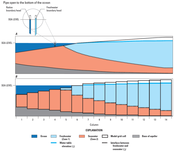
The MODFLOW SWI2 package is an optional package in MODFLOW-2005. It can be used to model 3D "vertically integrated variable-density groundwater flow and seawater intrusion in coastal multiaquifer systems."[1]
GMS provides an interface to the SWI2 package. The package can be turned on in the MODFLOW Packages dialog, accessible from the MODFLOW Global/Basic Package dialog. The package dialog can be accessed from the main MODFLOW menu or by right-clicking on the MODFLOW item in the Project Explorer.

A, cross section through a coastal aquifer with freshwater flowing from right to left and discharging seaward of the coastline; B, cross section through a coastal aquifer discretized using a single model layer. The position of the freshwater-seawater interface is also shown on A and B.[1]
Notes
- ^ a b Bakker, Mark, Schaars, Frans, Hughes, J.D., Langevin, C.D., and Dausman, A.M., (2013), Documentation of the Seawater Intrusion (SWI2) Package for MODFLOW: U.S. Geological Survey Techniques and Methods, book 6, chap. A46, 47 p.,, http://pubs.usgs.gov/tm/6a46/
| GMS – Groundwater Modeling System | ||
|---|---|---|
| Modules: | 2D Grid • 2D Mesh • 2D Scatter Point • 3D Grid • 3D Mesh • 3D Scatter Point • Boreholes • GIS • Map • Solid • TINs • UGrids | |
| Models: | FEFLOW • FEMWATER • HydroGeoSphere • MODAEM • MODFLOW • MODPATH • mod-PATH3DU • MT3DMS • MT3D-USGS • PEST • PHT3D • RT3D • SEAM3D • SEAWAT • SEEP2D • T-PROGS • ZONEBUDGET | |
| Aquaveo | ||
Retrieved from "https://www.xmswiki.com/index.php?title=GMS:SWI_Package&oldid=84944"
Hidden category: