WMS:Soil Type Coverage
The soil type coverage is similar to the land use coverage in that it can be used to map different model parameters (related to soil type) from polygonal coverages (usually imported from a GIS). The following is a list of operations that can be done using soil type coverages and the parameters that must be linked to soil IDs:
- Hydrologic soil group to map SCS Curve Numbers (requires the use of a land use coverage as well).
- Soil Type Number (must be = 0 for type A, 1 for type B, 2 for type C and 3 for type D).
- Runoff coefficients for the Rational Method (C in Q = CiA).
- Runoff coefficient.
- Green & Ampt parameters for infiltration modeling in HEC-1.
- Soil texture (soil name) to map SMA loss parameters.
- Hydraulic conductivity, percent impervious, percent effective.
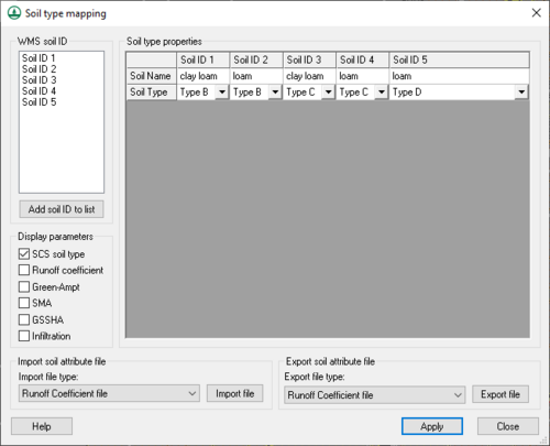
The user indicates which application(s) to use the soil type coverage for by selecting the appropriate toggle boxes in the Display parameters (lower left) section of the Soil Type Mapping dialog (shown below). A user may only define parameter values for the applications selected.
Each soil type polygon will have a soil type ID associated with it (a single integer number). In order to perform the correct mapping, it's necessary to link the appropriate soil type variables to each ID. WMS allows users to do this in one of two ways. First of all, with the soil type coverage active and having selected the appropriate polygon, a user can open the Soil Type Mapping dialog from the Feature Objects menu using the Attributes command, and then create new IDs and enter parameters for each ID. Secondly, a user can enter the data in a text file and then import it from within the same dialog.
Parameter values for soil type IDs are defined by selecting the ID in the WMS soil type ID text window and the parameter from the selected soil type properties text window, and then entering the value in the edit field.
If choosing to define all the data manually using the Soil Type Mapping dialog, most users will want to export the data to a file so that there is no need to reenter the data for future models using the same soil type parameter definitions.
Once the soil type parameters have been defined, soil type IDs can be assigned to polygons by first selecting the desired polygon(s) and then choosing the Attributes command from the Feature Object menu (or by double-clicking on the polygon) and choosing the appropriate ID from the WMS soil ID text window.
Once soil type IDs have been assigned to polygons and parameters linked to the soil type IDs, model parameters can be computed using the Compute GIS Attributes command from the Calculators menu in the Hydrologic Modeling module.
Related Topics
WMS – Watershed Modeling System | ||
|---|---|---|
| Modules: | Terrain Data • Drainage • Map • Hydrologic Modeling • River • GIS • 2D Grid • 2D Scatter |  |
| Models: | CE-QUAL-W2 • GSSHA • HEC-1 • HEC-HMS • HEC-RAS • HSPF • MODRAT • NSS • OC Hydrograph • OC Rational • Rational • River Tools • Storm Drain • SMPDBK • SWMM • TR-20 • TR-55 | |
| Toolbars: | Modules • Macros • Units • Digitize • Static Tools • Dynamic Tools • Drawing • Get Data Tools | |
| Aquaveo | ||
