GMS:LAK Package
| MODFLOW | |
|---|---|
| Pre-processing | |
| MODFLOW Commands | |
| Building a MODFLOW Model | |
| Map to MODFLOW | |
| Calibration | |
| Packages Supported in GMS | |
| Saving a MODFLOW Simulation | |
| Importing MODFLOW Files | |
| Unsupported MODFLOW Features | |
| Run MODFLOW | |
| Post-processing | |
| MODFLOW Display Options | |
| MODFLOW Post-Processing Viewing Options | |
| Reading a MODFLOW Simulation | |
| Tutorials | |
| Packages | |
| Flow: | BCF6, HUF, LPF, UPW |
| Solvers: | SMS |
| Other: | UZF1 |
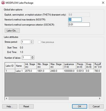
The Lake (LAK) package is a more sophisticated alternative to the typical approach of using the General Head package to simulate the effect of lakes and reservoirs on an aquifer. Comparing the Lake package to the GHB Package is similar to comparing the River package to the Stream package. With the GHB Package, the user defines the stage. With the Lake package, the stage is computed automatically based on the water budget. The water budget is a function of inflow, outflow, recharge, evaporation, etc. The storage capacity of the lake is determined automatically based on the lake geometry. Some of the cells defining the lake are allowed to go dry if the lake stage drops sufficiently.
The lake is also assumed to have lakebed sediments which affect the flow between the aquifer and the lake. The effect of the lakebed sediments is represented with a leakance term which includes the thickness and the hydraulic conductivity.
The Lake package includes an option that allows one to simulate "sublakes". This option makes it possible for the lake to partition into smaller, separated lakes as the lake stage drops.
The Theta term offers a choice between an explicit solution at 0.0, a semi-implicit solution between 0.0 and 1.0, or an implicit solution at 1.0.
For using the LAK package with MODFLOW-USG, the grid should have the same topology in all layers through which the water table fluctuates.
Terms
- Leakance – Represents the lakebed leakance. This is a function of hydraulic conductivity and lakebed thickness
- Bathymetry – A reference to a TIN from which the bathymetric elevations are derived.
- Sill Elev – The sill elevation at which the sublake begins to drain into the parent lake.
- Withdrawal – The volumetric rate, or flux, of water removal from a lake by means other than rainfall, evaporation, surface outflow, or ground-water seepage.
Adjust Cell Elevation
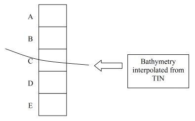
Lake polygons in a conceptual model include an option called Adjust Cell Elev. This option often results in thin cells and instability and should generally be avoided. Here's how it works. GMS interpolates a bathymetric elevation from the appropriate TIN and finds the cell where the top of the cell is above the bathymetric elevation and the bottom of the cell is below. After finding the intersecting cell, all cells above the point in question are marked as inactive (IBOUND = 0) and assigned with the appropriate lake ID. For the cell that intersects the bottom of the lake, the way the cell is handled depends on what layer it is in. If the cell is in the top layer, it is made inactive, marked as part of the lake, and the bottom elevation of the cell is adjusted to match the lake bottom. If the cell is in one of the lower layers, GMS first determines if the lake bottom is closer to the top of the cell or the bottom of the cell. If the lake bottom is closer to the top of the cell, the top elevation for the cell is adjusted to match the bottom of the lake and the cell is left as active and NOT marked as being in the interior of the lake. If the lake bottom is closer to the bottom of the cell, the bottom elevation of the cell is adjusted to match the lake bottom and the cell is marked as both inactive and inside of the lake.
| GMS – Groundwater Modeling System | ||
|---|---|---|
| Modules: | 2D Grid • 2D Mesh • 2D Scatter Point • 3D Grid • 3D Mesh • 3D Scatter Point • Boreholes • GIS • Map • Solid • TINs • UGrids | |
| Models: | FEFLOW • FEMWATER • HydroGeoSphere • MODAEM • MODFLOW • MODPATH • mod-PATH3DU • MT3DMS • MT3D-USGS • PEST • PHT3D • RT3D • SEAM3D • SEAWAT • SEEP2D • T-PROGS • ZONEBUDGET | |
| Aquaveo | ||

