WMS:TIN Breaklines
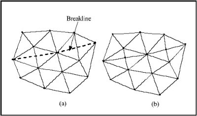
A breakline is a feature line or polyline representing a stream channel, ridge or some other feature to preserve in a TIN. In other words, a breakline is a series of edges that the triangles should conform to. Breaklines can be very useful when trying to eliminate unwanted pits on the interior of a TIN.
Breaklines can be processed using the Triangles | Insert Breakline(s) command from the TIN menu. Before selecting the command, one or more sequences of vertices defining the breakline(s) should be selected using the Select Vertices tool in the tool palette.
Breakline Options
Breakline options option are controlled in the TIN Options of the TINs menu. This dialog allows specifying either to interpolate the z values from the existing TIN or to get the z values from feature arcs. The elevations of the new vertices are based on a linear interpolation of the breakline segments. The locations of the new vertices are determined in such a way that the Delauney criterion is satisfied.
Related Topics
WMS – Watershed Modeling System | ||
|---|---|---|
| Modules: | Terrain Data • Drainage • Map • Hydrologic Modeling • River • GIS • 2D Grid • 2D Scatter |  |
| Models: | CE-QUAL-W2 • GSSHA • HEC-1 • HEC-HMS • HEC-RAS • HSPF • MODRAT • NSS • OC Hydrograph • OC Rational • Rational • River Tools • Storm Drain • SMPDBK • SWMM • TR-20 • TR-55 | |
| Toolbars: | Modules • Macros • Units • Digitize • Static Tools • Dynamic Tools • Drawing • Get Data Tools | |
| Aquaveo | ||
