WMS:Project Explorer Contents for GIS Module: Difference between revisions
No edit summary |
No edit summary |
||
| (20 intermediate revisions by the same user not shown) | |||
| Line 7: | Line 7: | ||
First, WMS reads and displays point, line, and polygon shapefiles as GIS vector data. These data can be converted to feature objects and WMS has a rich set of options for preserving, modifying, and converting attributes and geometry from shapefiles to feature objects in the map module of WMS. | First, WMS reads and displays point, line, and polygon shapefiles as GIS vector data. These data can be converted to feature objects and WMS has a rich set of options for preserving, modifying, and converting attributes and geometry from shapefiles to feature objects in the map module of WMS. | ||
Second, WMS has tools for reading, displaying, and converting several formats of raster and vector GIS data to other formats. WMS uses the [ | Second, WMS has tools for reading, displaying, and converting several formats of raster and vector GIS data to other formats. WMS uses the [https://www.gdal.org/ GDAL] library of functions to read and convert nearly all the formats that can be read and displayed by GDAL. This functionality is available for all WMS users who have a license that includes the GIS module. The GIS vector data read as a GDAL object can be converted to a WMS point, line, or polygon shapefile type so the data can be converted to feature objects and used in the hydrologic modeling projects. When selecting the [[Get_Online_Maps|Get Online Maps]] button in WMS, WMS loads an online map that is either a standard image, a palette-based raster (such as a land use grid), or an elevation raster (such as a DEM). | ||
Finally, if | Finally, if there is a current license to ArcMap that includes ArcObjects and ArcObjects have been enabled, WMS can read any data that ArcGIS can read. If ArcObjects is not enabled, WMS can still read several raster and vector data formats through GDAL. However, some formats only supported by ArcObjects cannot be read. | ||
Each type of data has a similar but different right-click menu that allows | Each type of data has a similar but different right-click menu that allows accessing some of the functions that are available. Some functionality is also available in the GIS module menus. Some menus are only available if ArcObjects has been enabled. | ||
A summary table listing the various types of data that can be read and displayed and some of the functionality available for the various types of data is shown below: | A summary table listing the various types of data that can be read and displayed and some of the functionality available for the various types of data is shown below: | ||
| Line 19: | Line 19: | ||
|- | |- | ||
| WMS Point Shapefiles | | WMS Point Shapefiles | ||
| [[ | | [[File:GIS Scatter Point Shapefile.svg|16 px]] | ||
| GIS Vector Data | | GIS Vector Data | ||
| | | | ||
| Line 26: | Line 26: | ||
* View object and entire shapefile attributes | * View object and entire shapefile attributes | ||
* Join .dbf file with the vector layer using a common ID | * Join .dbf file with the vector layer using a common ID | ||
* Convert to Vector GIS Data ( | * Convert to Vector GIS Data (GDAL) | ||
| WMS License with Map Module | | WMS License with Map Module | ||
|- | |- | ||
| WMS Line Shapefiles | | WMS Line Shapefiles | ||
| [[ | | [[File:GIS Stream Data Shapefile.svg|16 px]] | ||
| GIS Vector Data | | GIS Vector Data | ||
| | | | ||
| Line 37: | Line 37: | ||
* View object and entire shapefile attributes | * View object and entire shapefile attributes | ||
* Join .dbf file with the vector layer using a common ID | * Join .dbf file with the vector layer using a common ID | ||
* Convert to Vector GIS Data ( | * Convert to Vector GIS Data (GDAL) | ||
| WMS License with Map Module | | WMS License with Map Module | ||
|- | |- | ||
| WMS Polygon Shapefiles | | WMS Polygon Shapefiles | ||
| [[ | | [[File:GIS Polygon Data Shapefile.svg|16 px]] | ||
| GIS Vector Data | | GIS Vector Data | ||
| | | | ||
| Line 49: | Line 49: | ||
* Join .dbf file with the vector layer using a common ID | * Join .dbf file with the vector layer using a common ID | ||
* Join NRCS data (joins tables specific to NRCS SSURGO data with the shapefile) | * Join NRCS data (joins tables specific to NRCS SSURGO data with the shapefile) | ||
* Convert to Vector GIS Data ( | * Convert to Vector GIS Data (GDAL) | ||
| WMS License with Map Module | | WMS License with Map Module | ||
|- | |- | ||
| Line 100: | Line 100: | ||
|- | |- | ||
| Online Generic GIS Raster Image | | Online Generic GIS Raster Image | ||
| [[ | | [[File:DynamicImagery.svg|16 px]] | ||
| GIS Raster Data | | GIS Raster Data | ||
| | | | ||
| Line 133: | Line 133: | ||
|- | |- | ||
| ArcObjects Point File | | ArcObjects Point File | ||
| [[ | | [[File:GIS Scatter Point Shapefile.svg|16 px]] | ||
| GIS Vector Data | | GIS Vector Data | ||
| | | | ||
| Line 146: | Line 146: | ||
|- | |- | ||
| ArcObjects Arc File | | ArcObjects Arc File | ||
| [[ | | [[File:GIS Stream Data Shapefile.svg|16 px]] | ||
| GIS Vector Data | | GIS Vector Data | ||
| | | | ||
| Line 159: | Line 159: | ||
|- | |- | ||
| ArcObjects Polygon File | | ArcObjects Polygon File | ||
| [[ | | [[File:GIS Polygon Data Shapefile.svg|16 px]] | ||
| GIS Vector Data | | GIS Vector Data | ||
| | | | ||
| Line 193: | Line 193: | ||
|} | |} | ||
[[Image:GIS DataFolder.png]] | |||
Right-clicking on the main GIS Layers folder allows adding the various types of GIS data (open new GIS layers) or clear all data. If ArcObjects is enabled WMS cannot read the GIS data types. Right-click on the GIS Data folder and clear all the GIS data to disable ArcObjects and read GIS data using the '''Add GIS Data''' button or menu. With ArcObjects enabled, access exists to any type of data that can be read by ArcMap® and to some of the functionality of ArcMap® from inside of WMS. | |||
[[Image:GIS Right-ClickMenu1.png]] | |||
[[ | Right-clicking on a GIS layer has commands to '''Delete''', '''Rename''', '''Zoom to layer''', view/set '''Properties''', '''[[WMS:GIS Tables|Open Attribute Table]]''', or '''Set Layer Transparency'''. If the layer is a vector data layer then there is an option to '''[[WMS:GIS Tables|Join Table to Layer]]'''. If the layer is a grid, an options exist to '''Write DEM ASCII File''' or '''Convert to DEM'''. | ||
The properties are the identical properties available from ArcGIS. | |||
[[Image:GIS DataRight-ClickMenu.png]] | |||
==Deleting GIS Data Layers== | |||
A GIS Data layer can be deleted by right-clicking on the layer folder in the Project Explorer and selecting the '''Delete''' command. | |||
==Related Topics== | ==Related Topics== | ||
| Line 213: | Line 215: | ||
{{WMSMain}} | {{WMSMain}} | ||
[[Category:WMS GIS|P]] | |||
[[Category:Project Explorer|GIS]] | |||
[[Category:WMS Menus]] | |||
[[Category:Needs Update]] | |||
Latest revision as of 20:36, 23 January 2019
GIS layers are organized and displayed in the GIS module. This module can be used for displaying and converting GIS data, but data in this module is not meant to be used for watershed analysis directly.
There are two general types of GIS layers that can be displayed, and there are various ways of reading GIS data. The two general types of GIS data include raster and vector GIS data. WMS can read either raster or vector GIS data into the GIS module and these data can be converted to various formats for use both inside and outside of WMS.
To understand how data is stored and projected under the GIS module, it is important to understand how WMS reads the various types of raster and vector GIS data.
First, WMS reads and displays point, line, and polygon shapefiles as GIS vector data. These data can be converted to feature objects and WMS has a rich set of options for preserving, modifying, and converting attributes and geometry from shapefiles to feature objects in the map module of WMS.
Second, WMS has tools for reading, displaying, and converting several formats of raster and vector GIS data to other formats. WMS uses the GDAL library of functions to read and convert nearly all the formats that can be read and displayed by GDAL. This functionality is available for all WMS users who have a license that includes the GIS module. The GIS vector data read as a GDAL object can be converted to a WMS point, line, or polygon shapefile type so the data can be converted to feature objects and used in the hydrologic modeling projects. When selecting the Get Online Maps button in WMS, WMS loads an online map that is either a standard image, a palette-based raster (such as a land use grid), or an elevation raster (such as a DEM).
Finally, if there is a current license to ArcMap that includes ArcObjects and ArcObjects have been enabled, WMS can read any data that ArcGIS can read. If ArcObjects is not enabled, WMS can still read several raster and vector data formats through GDAL. However, some formats only supported by ArcObjects cannot be read.
Each type of data has a similar but different right-click menu that allows accessing some of the functions that are available. Some functionality is also available in the GIS module menus. Some menus are only available if ArcObjects has been enabled.
A summary table listing the various types of data that can be read and displayed and some of the functionality available for the various types of data is shown below:
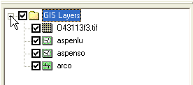
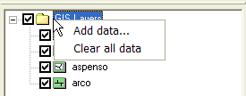
Right-clicking on the main GIS Layers folder allows adding the various types of GIS data (open new GIS layers) or clear all data. If ArcObjects is enabled WMS cannot read the GIS data types. Right-click on the GIS Data folder and clear all the GIS data to disable ArcObjects and read GIS data using the Add GIS Data button or menu. With ArcObjects enabled, access exists to any type of data that can be read by ArcMap® and to some of the functionality of ArcMap® from inside of WMS.
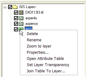
Right-clicking on a GIS layer has commands to Delete, Rename, Zoom to layer, view/set Properties, Open Attribute Table, or Set Layer Transparency. If the layer is a vector data layer then there is an option to Join Table to Layer. If the layer is a grid, an options exist to Write DEM ASCII File or Convert to DEM.
The properties are the identical properties available from ArcGIS.
Deleting GIS Data Layers
A GIS Data layer can be deleted by right-clicking on the layer folder in the Project Explorer and selecting the Delete command.
Related Topics
WMS – Watershed Modeling System | ||
|---|---|---|
| Modules: | Terrain Data • Drainage • Map • Hydrologic Modeling • River • GIS • 2D Grid • 2D Scatter |  |
| Models: | CE-QUAL-W2 • GSSHA • HEC-1 • HEC-HMS • HEC-RAS • HSPF • MODRAT • NSS • OC Hydrograph • OC Rational • Rational • River Tools • Storm Drain • SMPDBK • SWMM • TR-20 • TR-55 | |
| Toolbars: | Modules • Macros • Units • Digitize • Static Tools • Dynamic Tools • Drawing • Get Data Tools | |
| Aquaveo | ||


