WMS:What's new in WMS version 11.3: Difference between revisions
From XMS Wiki
Jump to navigationJump to search
| Line 59: | Line 59: | ||
** [https://www.whiteboxgeo.com/manual/wbt_book/available_tools/geomorphometric_analysis.html#FeaturePreservingSmoothing Smooth raster] | ** [https://www.whiteboxgeo.com/manual/wbt_book/available_tools/geomorphometric_analysis.html#FeaturePreservingSmoothing Smooth raster] | ||
** [[Strahler Order Basins Tool | Strahler order basins]] | ** [[Strahler Order Basins Tool | Strahler order basins]] | ||
** [ | ** [[Subbasins Tool | Subbasins]] | ||
** [[Trim_Raster_Tool|Trim raster]] | ** [[Trim_Raster_Tool|Trim raster]] | ||
** [[Watershed Delineation Tool | Watershed delineation]] | ** [[Watershed Delineation Tool | Watershed delineation]] | ||
Latest revision as of 03:41, 2 November 2024
| This contains information about functionality available starting at WMS version 11.3. The content may not apply to other versions. |
The WMS software development team is excited about the release of WMS 11.3! This page lists the exciting new features that have been added to WMS 11.3.
What's new in WMS 11.3
General
- Added a search box to the Recent Files dialog to make it easier to find recent projects.
- Updates to the coverage cleaner in the Clean Options dialog which include:
- Cleaning algorithm is now significantly faster on large coverages.
- Improved user interface.
- Updated Map Locator tool.
GSSHA
- Updated GSSHA executable to version 8.0.018.
- Permafrost parameters have been added for use with GSSHA models in WMS.
Toolbox
- New coverage tools (beta):
- New raster tools (beta):
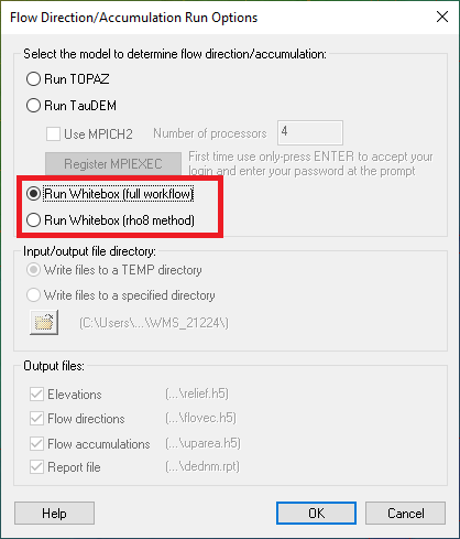
- New flow direction/flow accumulation computation tools (a rho8 and a D8 "full workflow" algorithm) based on the Whitebox suite of tools that run orders of magnitude faster than the TOPAZ and even TauDEM flow direction/flow accumulation computation packages. This tool runs directly from the Run Flow Directions/Accumulations menu item as alternate options in the dialog:
- Bilateral filter
- Blend raster to edges
- Breach depressions
- Breach depressions (least cost method)
- Clip raster from elevations
- Conservative smoothing filter
- D8 flow accumulation
- D8 flow directions
- Edge preserving mean filter
- Edit elevations
- Extend raster
- Extract streams
- Feature preserving smoothing
- Fill depressions
- Fill nodata
- Flow accumulation full workflow
- Gaussian filter
- Isobasins
- Mean filter
- Merge elevation rasters
- Raster difference
- Reproject raster
- Rho8 flow accumulation
- Rho8 flow directions
- Smooth raster
- Strahler order basins
- Subbasins
- Trim raster
- Watershed delineation
WMS – Watershed Modeling System | ||
|---|---|---|
| Modules: | Terrain Data • Drainage • Map • Hydrologic Modeling • River • GIS • 2D Grid • 2D Scatter |  |
| Models: | CE-QUAL-W2 • GSSHA • HEC-1 • HEC-HMS • HEC-RAS • HSPF • MODRAT • NSS • OC Hydrograph • OC Rational • Rational • River Tools • Storm Drain • SMPDBK • SWMM • TR-20 • TR-55 | |
| Toolbars: | Modules • Macros • Units • Digitize • Static Tools • Dynamic Tools • Drawing • Get Data Tools | |
| Aquaveo | ||
