GMS:UPW Package
| MODFLOW | |
|---|---|
| Pre-processing | |
| MODFLOW Commands | |
| Building a MODFLOW Model | |
| Map to MODFLOW | |
| Calibration | |
| Packages Supported in GMS | |
| Saving a MODFLOW Simulation | |
| Importing MODFLOW Files | |
| Unsupported MODFLOW Features | |
| Run MODFLOW | |
| Post-processing | |
| MODFLOW Display Options | |
| MODFLOW Post-Processing Viewing Options | |
| Reading a MODFLOW Simulation | |
| Tutorials | |
| Packages | |
| Flow: | BCF6, HUF, LPF, UPW |
| Solvers: | SMS |
| Other: | UZF1 |
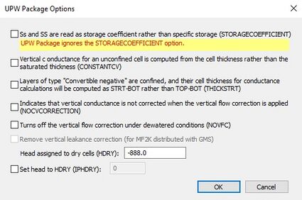
The UPW (UPstream Weighting) flow package can only be used in a MODFLOW-NWT model. The UPW flow package is based on the LPF package but differs in that the rewetting and vertical conductance correction options are not available. Also, in a simulation including extraction wells with the LPF package, as soon as the cell goes dry the pumping stops, but with the UPW package the pumping continues at a reduced rate because of the different way wetting and drying are handled. By default the UPW package does not assign the HDRY value to cells that go dry unless the IPHDRY variable is turned on. It also differs from the LPF package in that it smoothes the horizontal conductance and storage change functions to have a continuous derivatives so they can be solved by the Newton method. Using the UPW package requires using the NWT solver, though the NWT solver can be used with the LPF package instead.
The UPW Package is available through the MODFLOW-NWT tutorial.
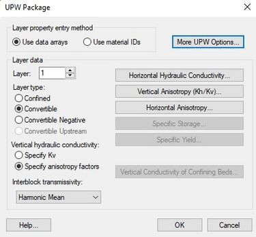
Use data arrays
- This option allows entering conductivities on a layer-by-layer basis. When this option is chosen, the Horizontal Hyd. Conductivity, Vertical Hyd. Conductivity and Horizontal Anisotropy buttons will be available.
Use material ids
- This options uses material sets in the place of property arrays. Property values are entered on a material-by-material basis. When MODFLOW files are saved, GMS internally replaces the correct values from the materials to the property arrays. When this option is chose, the property array buttons are replaced with the Material Properties and Material IDs buttons.
Layer
- This field displays the current layer. Selecting any of the input array buttons will display the corresponding layer initially. For multiple layer models, this field can be incremented or decremented to show other layers.
Layer type
- This radio group selects the layer type for the current layer. By default, all layers are convertible (where the layer can be either confined or unconfined depending on the elevation of the computed water table). Here layer type can be changed to confined, convertible, convertible negative, and convertible upstream. Only one layer type can be assigned to each grid layer.
Vertical hydraulic conductivity
- The UPW package has the option to enter vertical hydraulic conductivity values as either actual hydraulic conductivity values or as anisotropy factors dependant on horizontal hydraulic conductivity. Vertical anisotropy (VKA) "is the ratio of horizontal to vertical hydraulic conductivity. In this case, HK is divided by VKA to obtain VK, and values of VKA typically are greater than or equal to 1.0."[1]
- These options are only available for multi-layer models.
Interblock transmissivity
- The method used for computing interblock transmissivity is specified using the pull-down list in the middle right portion of the UPW Package dialog. The pulldown list includes, Harmonic Mean, Log Mean, and Arith t X log(k).
More UPW Options
- Clicking on the More UPW Options button brings up the UPW Package Options dialog where it is possible to remove vertical leakance correction or set a head value for dry cells.
Layer Data Arrays
The seven buttons in the middle-right portion of the dialog represent layer data arrays such as elevations and hydraulic conductivity. Each of the seven buttons brings up the MODFLOW Array Editor. Not all of the data arrays need to be specified for each layer. Some arrays such as specific storage and specific yield are only required for transient models.
External Links
| GMS – Groundwater Modeling System | ||
|---|---|---|
| Modules: | 2D Grid • 2D Mesh • 2D Scatter Point • 3D Grid • 3D Mesh • 3D Scatter Point • Boreholes • GIS • Map • Solid • TINs • UGrids | |
| Models: | FEFLOW • FEMWATER • HydroGeoSphere • MODAEM • MODFLOW • MODPATH • mod-PATH3DU • MT3DMS • MT3D-USGS • PEST • PHT3D • RT3D • SEAM3D • SEAWAT • SEEP2D • T-PROGS • ZONEBUDGET | |
| Aquaveo | ||
- ^ Harbaugh, A.W., Banta, E.R., Hill, M.C., McDonald, M.G. (2000), MODFLOW-2000, the U.S. Geological Survey modular ground-water model — User guide to modularization concepts and the Ground-Water Flow Process, Open-File Report 00-92, U.S. Geological Survey, p. 62, http://water.usgs.gov/nrp/gwsoftware/modflow2000/ofr00-92.pdf

