GMS:MF6 MVT Package
From XMS Wiki
(diff) ← Older revision | Latest revision (diff) | Newer revision → (diff)
| MODFLOW 6 is currently in Beta release for GMS Some features and capabilities of MODFLOW 6 are still in development for GMS. |
| MODFLOW 6 | |
|---|---|
| Models & Tools | |
|
GWF Model GWT Model Cell Properties Dialog Zone File | |
| Packages | |
| Flow: | GNC, HFB, NPF |
| GWF: |
BUY, CHD, CSUB, DRN, EVT, GHB, LAK, MAW, MVR, OBS, RCH,RIV, SFR, STO, UZF, WEL |
| GWT: |
ADV, CNC, DSP FMI, IC, IST, LKT, MDT, MST, MVT, MWT, OBS, SFT, SRC,SSM, UZT |
| Other |
DIS, DISU, DISV, IMS, OC, TDIS, PEST |
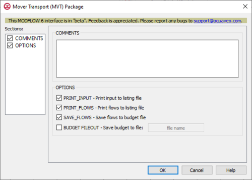
The Mover Transport (MVT) Package dialog is accessed by double-clicking on the MVT package under a MODFLOW 6 simulation in the Project Explorer. It contains the following sections and options:
- Sections list – A list of sections that can be turned on or off:
- COMMENTS – Turn on to make the COMMENTS section visible.
- OPTIONS – Turn on to make the OPTIONS section visible.
- COMMENTS section – Enter general alphanumeric comments. Comments entered here get written at the top of the file, preceded by a '#' symbol.
- OPTIONS section – Options and settings:
- PRINT_INPUT – This indicates that the list of mover information input will be printed to the listing file immediately after it is read.
- PRINT_FLOWS – This indicates that the list of lake flow rates will be printed to the listing file. Flow rates will be printed for every stress period time step that has been specified by "BUDGET PRINT" in Output Control. If PRINT_FLOWS has been specified but there is no Output Control option, then flow rates will be printed for the last time step of each stress period.
- SAVE_FLOWS – This indicates that lake flow terms will be saved to a budget file (specified in Output Control with "BUDGET FILEOUT").
- BUDGET FILEOUT – This allows budget information to be saved to a specifically defined binary output file.
Related Topics
| GMS – Groundwater Modeling System | ||
|---|---|---|
| Modules: | 2D Grid • 2D Mesh • 2D Scatter Point • 3D Grid • 3D Mesh • 3D Scatter Point • Boreholes • GIS • Map • Solid • TINs • UGrids | |
| Models: | FEFLOW • FEMWATER • HydroGeoSphere • MODAEM • MODFLOW • MODPATH • mod-PATH3DU • MT3DMS • MT3D-USGS • PEST • PHT3D • RT3D • SEAM3D • SEAWAT • SEEP2D • T-PROGS • ZONEBUDGET | |
| Aquaveo | ||
