GMS:Parameters: Difference between revisions
From XMS Wiki
Jump to navigationJump to search
No edit summary |
|||
| Line 13: | Line 13: | ||
For example, a model may have four K zones and three recharge zones. The four K zones would be marked by assigning -100, -200, -300, and -400 to the cells in the K array for each of the four zones. Likewise, the recharge zones would be marked by assigning -500, -600, and -700 to the appropriate cells in the recharge array. | For example, a model may have four K zones and three recharge zones. The four K zones would be marked by assigning -100, -200, -300, and -400 to the cells in the K array for each of the four zones. Likewise, the recharge zones would be marked by assigning -500, -600, and -700 to the appropriate cells in the recharge array. | ||
Key values can be assigned either by editing the cell array values directly in the 3D grid module or by assigning the values to a set of [[GMS:Feature_Objects|polygons or arcs]] in the [[GMS:Feature_Objects#Conceptual_Models|conceptual model]] and selecting the [[GMS:Map_to_MODFLOW|Map -> MODFLOW]] command. | Key values can be assigned either by editing the cell array values directly in the 3D grid module or by assigning the values to a set of [[GMS:Feature_Objects|polygons or arcs]] in the [[GMS:Feature_Objects#Conceptual_Models|conceptual model]] and selecting the [[GMS:Map_to_MODFLOW|'''''Map -> MODFLOW''''']] command. | ||
When MODFLOW is running and data is read from the [[GMS:MODFLOW_with_HDF5|HDF5]] file, if one of the parameter key values is found in the data then the parameter value is substituted into the array or list. | When MODFLOW is running and data is read from the [[GMS:MODFLOW_with_HDF5|HDF5]] file, if one of the parameter key values is found in the data then the parameter value is substituted into the array or list. | ||
| Line 40: | Line 40: | ||
{{hide in print|[[Image:zonation.gif|frame|none|300px]] | {{hide in print|[[Image:zonation.gif|frame|none|300px]] | ||
}} | }} | ||
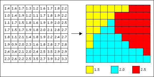
Zonation is most easily accomplished in GMS by assigning key values to polygons in the map module. It can also be accomplished by assigning key values to a selected set of cells in the 3D grid module using the [[GMS:Cell Properties|Cell Attributes]] command. | Zonation is most easily accomplished in GMS by assigning key values to polygons in the map module. It can also be accomplished by assigning key values to a selected set of cells in the 3D grid module using the [[GMS:Cell Properties|'''''Cell Attributes''''']] command. | ||
==== Pilot points ==== | ==== Pilot points ==== | ||
| Line 47: | Line 47: | ||
===Creating a parameter list=== | ===Creating a parameter list=== | ||
The list of parameters is defined using the [[GMS:Parameter_Dialog|Parameter Dialog]]. In general, the number of parameters should be less than the number of observations. However, if the user chooses to use [[GMS:Pilot Points|pilot points]] with PEST in regularization mode, then the number of parameters does not have to be less than the number of observations. | The list of parameters is defined using the [[GMS:Parameter_Dialog|''Parameter'' Dialog]]. In general, the number of parameters should be less than the number of observations. However, if the user chooses to use [[GMS:Pilot Points|pilot points]] with PEST in regularization mode, then the number of parameters does not have to be less than the number of observations. | ||
==== Legal MODFLOW Parameters ==== | ==== Legal MODFLOW Parameters ==== | ||
