WMS:HY8 Modeling Wizard: Difference between revisions
No edit summary |
No edit summary |
||
| (One intermediate revision by the same user not shown) | |||
| Line 1: | Line 1: | ||
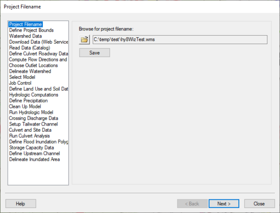
[[Image:HY8ModelingWizardDialog.png|thumb|none|left|550 px|The HY8 Modeling Wizard showing the ''Project Filename'' dialog.]] | :[[Image:HY8ModelingWizardDialog.png|thumb|none|left|550 px|The HY8 Modeling Wizard showing the ''Project Filename'' dialog.]] | ||
The WMS HY-8 Modeling Wizard ([[File:HY8 | The WMS HY-8 Modeling Wizard ([[File:HY8 ModelingWizardIcon.svg|16 px]]) is a simple tool that guides through all the steps involved in creating a hydrologic model and routing the results from this model through a culvert. It can be accessed by selecting the HY-8 modeling wizard tool in the [[WMS:Get Data Toolbar|Get Data Toolbar]] ([[Image:GetDataToolbar1.png]]). | ||
== Steps == | == Steps == | ||
Latest revision as of 16:38, 27 February 2018
The WMS HY-8 Modeling Wizard (![]() ) is a simple tool that guides through all the steps involved in creating a hydrologic model and routing the results from this model through a culvert. It can be accessed by selecting the HY-8 modeling wizard tool in the Get Data Toolbar (
) is a simple tool that guides through all the steps involved in creating a hydrologic model and routing the results from this model through a culvert. It can be accessed by selecting the HY-8 modeling wizard tool in the Get Data Toolbar (![]() ).
).
Steps
The following steps are included in the HY-8 modeling wizard:
- Project Filename
- Define Project Bounds
- Watershed Data
- Download Data (Web Service Client)
- Read Data (Catalog)
- Define Culvert Roadway Data
- Compute Flow Directions and Flow Accumulations
- Choose Outlet Locations
- Delineate Watershed
- Select Model
- Job Control
- Define Land Use and Soil Data
- Hydrologic Computations
- Define Precipitation
- Clean Up Model
- Run Hydrologic Model
- Crossing Discharge Data
- Setup Tailwater Channel
- Culvert and Site Data
- Run Culvert Analysis
- Define Flood Inundation Polygon
- Storage Capacity Data
- Define Upstream Channel
- Delineate Inundated Area
General Information
If wanting to see where each variable for the HY-8 model originates in the WMS HY-8 modeling wizard, please read the following page: Path of Data from WMS To HY8.
HY8 Modeling Wizard Steps: Project Filename · Define Project Bounds · Watershed Data · Download Data (Web Service Client) · Read Data (Catalog) · Define Culvert Roadway Data · Compute Flow Directions and Flow Accumulations · Choose Outlet Locations · Delineate Watershed · Select Model · Job Control · Define Land Use and Soil Data · Hydrologic Computations · Define Precipitation · Clean Up Model · Run Hydrologic Model · Crossing Discharge Data · Setup Tailwater Channel · Culvert and Site Data · Run Culvert Analysis · Define Flood Inundation Polygon · Storage Capacity Data · Define Upstream Channel · Delineate Inundated Area
WMS – Watershed Modeling System | ||
|---|---|---|
| Modules: | Terrain Data • Drainage • Map • Hydrologic Modeling • River • GIS • 2D Grid • 2D Scatter |  |
| Models: | CE-QUAL-W2 • GSSHA • HEC-1 • HEC-HMS • HEC-RAS • HSPF • MODRAT • NSS • OC Hydrograph • OC Rational • Rational • River Tools • Storm Drain • SMPDBK • SWMM • TR-20 • TR-55 | |
| Toolbars: | Modules • Macros • Units • Digitize • Static Tools • Dynamic Tools • Drawing • Get Data Tools | |
| Aquaveo | ||
