WMS:Storage Capacity Data
The Storage Capacity Data step is used to define storage capacity data and to route the hydrograph at the outlet through the culvert.
Help
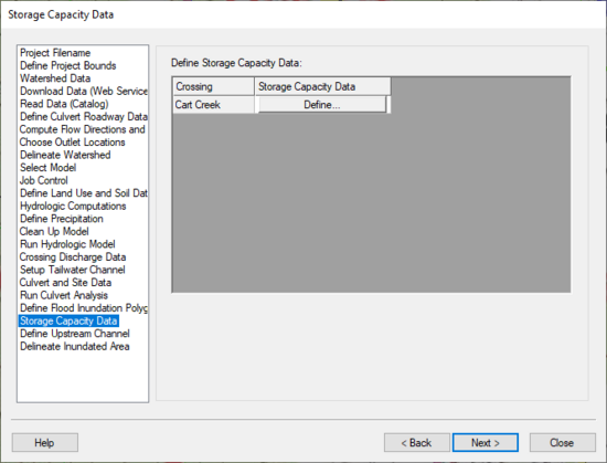
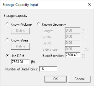
This step in the wizard lists all the crossings in the HY-8 coverage and allows defining storage capacity data for each of the crossings. The elevation-volume curve is defined from the DEM and the outlet/watershed boundary or the flood inundation polygon associated with the crossing. The elevations are defined from the headwater elevations in the HY-8 analysis. Alternatively, geometry of the area can be defined and the elevation-volume curve can be computed from this geometry or an elevation-area curve can be defined and the volume can be computed from this curve (a fourth option is that the storage can be entered directly into the storage capacity data dialog). When clicking on the Define button from the wizard, the Storage Capacity Input dialog appears, shown below:
In this dialog, select the option to use the DEM (this is the default if a DEM exists) to compute the volumes at each water surface elevation. Alternatively, enter the geometry of the basin upstream of the culvert or an elevation-area curve. If the Known Area option is selected, manually enter the area at each of the headwater elevations computed by HY-8.
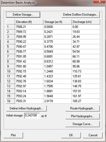
After exiting the define storage dialog, the Detention Basin Analysis dialog shows the elevation-storage-discharge chart in an FHWA Hydraulic Toolbox dialog and allows viewing and editing the routed hydrograph and its associated data:
HY8 Modeling Wizard Steps: Project Filename · Define Project Bounds · Watershed Data · Download Data (Web Service Client) · Read Data (Catalog) · Define Culvert Roadway Data · Compute Flow Directions and Flow Accumulations · Choose Outlet Locations · Delineate Watershed · Select Model · Job Control · Define Land Use and Soil Data · Hydrologic Computations · Define Precipitation · Clean Up Model · Run Hydrologic Model · Crossing Discharge Data · Setup Tailwater Channel · Culvert and Site Data · Run Culvert Analysis · Define Flood Inundation Polygon · Storage Capacity Data · Define Upstream Channel · Delineate Inundated Area
| [hide] WMS – Watershed Modeling System | ||
|---|---|---|
| Modules: | Terrain Data • Drainage • Map • Hydrologic Modeling • River • GIS • 2D Grid • 2D Scatter |  |
| Models: | CE-QUAL-W2 • GSSHA • HEC-1 • HEC-HMS • HEC-RAS • HSPF • MODRAT • NSS • OC Hydrograph • OC Rational • Rational • River Tools • Storm Drain • SMPDBK • SWMM • TR-20 • TR-55 | |
| Toolbars: | Modules • Macros • Units • Digitize • Static Tools • Dynamic Tools • Drawing • Get Data Tools | |
| Aquaveo | ||


