WMS:Delineate Inundated Area: Difference between revisions
No edit summary |
(→Help) |
||
| Line 7: | Line 7: | ||
The two delineation options are to delineate the entire hydrograph or to delineate only the design discharge. In either case, options such as the search radius set in the '''floodplain delineation options''' are used to delineate the floodplain. | The two delineation options are to delineate the entire hydrograph or to delineate only the design discharge. In either case, options such as the search radius set in the '''floodplain delineation options''' are used to delineate the floodplain. | ||
When WMS delineates the floodplain for each culvert crossing, it creates a 2D scatter set with 1 water surface elevation point at the upstream end of the culvert and at the specified distance along the upstream arc. The water surface elevation point interpolation interval is defaulted such that 20 solution points show up along the length of the upstream arc, but | When WMS delineates the floodplain for each culvert crossing, it creates a 2D scatter set with 1 water surface elevation point at the upstream end of the culvert and at the specified distance along the upstream arc. The water surface elevation point interpolation interval is defaulted such that 20 solution points show up along the length of the upstream arc, but a user can edit this interpolation interval. When the '''Delineate''' button is pressed, WMS creates a new 2D scattered dataset with elevation points at the upstream end of the culvert and at the specified interval along the upstream arc. WMS then populates a headwater elevation dataset in the 2D scattered dataset with the headwater values from the routed hydrograph or from the design discharge. Then WMS delineates the floodplain at each time step for a routed hydrograph or at a single time step for the design discharge. | ||
{{WMSHy8ModWizard}} | {{WMSHy8ModWizard}} | ||
{{WMSMain}} | {{WMSMain}} | ||
[[Category:WMS To HY8|D]] | [[Category:WMS To HY8|D]] | ||
Revision as of 14:17, 16 September 2014
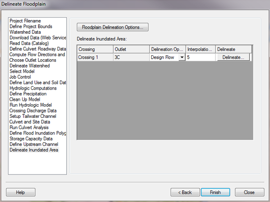
The Delineate Inundated Area step is used to delineate the floodplain corresponding to the culvert's design flow or hydrograph at each culvert crossing.
Help
The two delineation options are to delineate the entire hydrograph or to delineate only the design discharge. In either case, options such as the search radius set in the floodplain delineation options are used to delineate the floodplain.
When WMS delineates the floodplain for each culvert crossing, it creates a 2D scatter set with 1 water surface elevation point at the upstream end of the culvert and at the specified distance along the upstream arc. The water surface elevation point interpolation interval is defaulted such that 20 solution points show up along the length of the upstream arc, but a user can edit this interpolation interval. When the Delineate button is pressed, WMS creates a new 2D scattered dataset with elevation points at the upstream end of the culvert and at the specified interval along the upstream arc. WMS then populates a headwater elevation dataset in the 2D scattered dataset with the headwater values from the routed hydrograph or from the design discharge. Then WMS delineates the floodplain at each time step for a routed hydrograph or at a single time step for the design discharge.
HY8 Modeling Wizard Steps: Project Filename · Define Project Bounds · Watershed Data · Download Data (Web Service Client) · Read Data (Catalog) · Define Culvert Roadway Data · Compute Flow Directions and Flow Accumulations · Choose Outlet Locations · Delineate Watershed · Select Model · Job Control · Define Land Use and Soil Data · Hydrologic Computations · Define Precipitation · Clean Up Model · Run Hydrologic Model · Crossing Discharge Data · Setup Tailwater Channel · Culvert and Site Data · Run Culvert Analysis · Define Flood Inundation Polygon · Storage Capacity Data · Define Upstream Channel · Delineate Inundated Area
WMS – Watershed Modeling System | ||
|---|---|---|
| Modules: | Terrain Data • Drainage • Map • Hydrologic Modeling • River • GIS • 2D Grid • 2D Scatter |  |
| Models: | CE-QUAL-W2 • GSSHA • HEC-1 • HEC-HMS • HEC-RAS • HSPF • MODRAT • NSS • OC Hydrograph • OC Rational • Rational • River Tools • Storm Drain • SMPDBK • SWMM • TR-20 • TR-55 | |
| Toolbars: | Modules • Macros • Units • Digitize • Static Tools • Dynamic Tools • Drawing • Get Data Tools | |
| Aquaveo | ||
