WMS:Setup Tailwater Channel: Difference between revisions
No edit summary |
No edit summary |
||
| Line 14: | Line 14: | ||
If the irregular channel type is selected, a button that allows you to enter a cross section using the HY-8 irregular tailwater channel editor and then assigns this cross section to the tailwater channel. | If the irregular channel type is selected, a button that allows you to enter a cross section using the HY-8 irregular tailwater channel editor and then assigns this cross section to the tailwater channel. | ||
For more information on how WMS uses this data to set the HY8 Roadway Data, please see: [[WMS:Path_of_Data_from_WMS_To_HY8#Tailwater_Data|Path of Data from WMS to HY8]] | |||
{{WMSHy8ModWizard}} | {{WMSHy8ModWizard}} | ||
{{WMSMain}} | {{WMSMain}} | ||
Revision as of 18:54, 15 June 2011
Overview
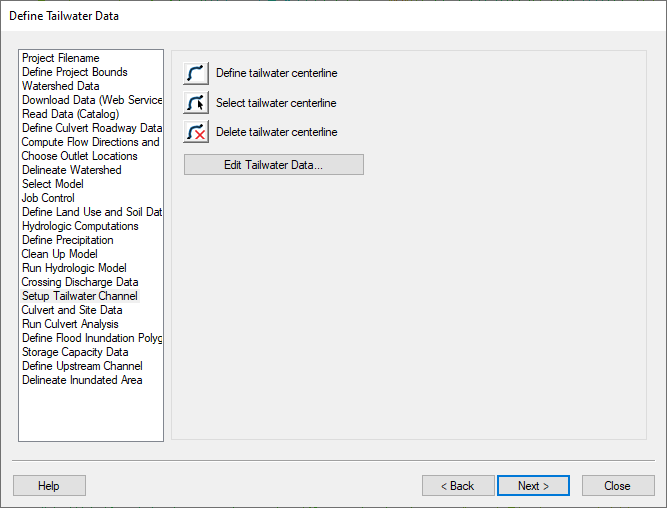
The Setup Tailwater Channel step is used to allow users to define a tailwater channel in much the same way as defining a roadway centerline or a culvert crossing centerline in a previous wizard step.
Help
When clicking on the define tailwater centerline button, WMS either gets the HY8 coverage and makes it the active coverage or creates a new HY8 coverage if one does not exist and make this new coverage the active coverage. You should create tailwater centerline arcs in the HY8 coverage. When creating the tailwater centerline arcs, start at the downstream end of the culvert crossing arc and create an arc downstream from that location.
If no tailwater arcs are selected, clicking on the Edit Tailwater Data... button selects all the tailwater arcs in the HY8 coverage and brings up the arc attributes for these arcs. If tailwater arcs are selected, only the selected tailwater arc attributes are shown. These attributes are shown in the arc attribute spreadsheet format.
After creating tailwater arcs, values for channel slope and channel invert elevation are defaulted from the background DEM data, using the elevation at the most upstream end of the tailwater arc. Users need to enter values for other parameters such as bottom width, side slopes, and roughness.
If the irregular channel type is selected, a button that allows you to enter a cross section using the HY-8 irregular tailwater channel editor and then assigns this cross section to the tailwater channel.
For more information on how WMS uses this data to set the HY8 Roadway Data, please see: Path of Data from WMS to HY8
HY8 Modeling Wizard Steps: Project Filename · Define Project Bounds · Watershed Data · Download Data (Web Service Client) · Read Data (Catalog) · Define Culvert Roadway Data · Compute Flow Directions and Flow Accumulations · Choose Outlet Locations · Delineate Watershed · Select Model · Job Control · Define Land Use and Soil Data · Hydrologic Computations · Define Precipitation · Clean Up Model · Run Hydrologic Model · Crossing Discharge Data · Setup Tailwater Channel · Culvert and Site Data · Run Culvert Analysis · Define Flood Inundation Polygon · Storage Capacity Data · Define Upstream Channel · Delineate Inundated Area
WMS – Watershed Modeling System | ||
|---|---|---|
| Modules: | Terrain Data • Drainage • Map • Hydrologic Modeling • River • GIS • 2D Grid • 2D Scatter |  |
| Models: | CE-QUAL-W2 • GSSHA • HEC-1 • HEC-HMS • HEC-RAS • HSPF • MODRAT • NSS • OC Hydrograph • OC Rational • Rational • River Tools • Storm Drain • SMPDBK • SWMM • TR-20 • TR-55 | |
| Toolbars: | Modules • Macros • Units • Digitize • Static Tools • Dynamic Tools • Drawing • Get Data Tools | |
| Aquaveo | ||
