WMS:Path of Data from WMS To HY8: Difference between revisions
| Line 3: | Line 3: | ||
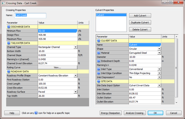
The HY8 Modeling Wizard in WMS gathers data to setup an HY8 model. Some data can be changed at multiple locations, and all variables can be changed in the HY-8 model when the model is setup. This data is categorized as follows: Discharge Data, Tailwater Data, Roadway Data, Culvert Data, and Site Data. These categories can be seen in the HY-8 interface. | The HY8 Modeling Wizard in WMS gathers data to setup an HY8 model. Some data can be changed at multiple locations, and all variables can be changed in the HY-8 model when the model is setup. This data is categorized as follows: Discharge Data, Tailwater Data, Roadway Data, Culvert Data, and Site Data. These categories can be seen in the HY-8 interface. | ||
[[Image:HY8EditCrossing.png|thumb|none|left|600 px|''Crossing Data'' dialog.]] | [[Image:HY8EditCrossing.png|thumb|none|left|600 px|''Crossing Data'' dialog in the HY8 Modeling Wizard.]] | ||
| Line 9: | Line 9: | ||
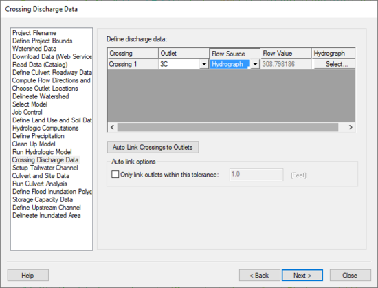
This information is pulled from the HY-8 Wizard on step [[WMS:Crossing Discharge Data|Crossing Discharge Data]]. | This information is pulled from the HY-8 Wizard on step [[WMS:Crossing Discharge Data|Crossing Discharge Data]]. | ||
[[Image:HY8ModelingWizardCrossingDischargeData.png]] | [[Image:HY8ModelingWizardCrossingDischargeData.png|thumb|none|left|550 px|''Crossing Discharge Data'' dialog in the HY8 Modeling Wizard.]] | ||
If the user specifies the flow source as 'Design Flow', the minimum flow value will be zero and the design and maximum flow value will be the value entered by the user. | If the user specifies the flow source as 'Design Flow', the minimum flow value will be zero and the design and maximum flow value will be the value entered by the user. | ||
Revision as of 15:30, 25 September 2013
The Path of Data from WMS to HY8 in the HY8 Modeling Wizard
The HY8 Modeling Wizard in WMS gathers data to setup an HY8 model. Some data can be changed at multiple locations, and all variables can be changed in the HY-8 model when the model is setup. This data is categorized as follows: Discharge Data, Tailwater Data, Roadway Data, Culvert Data, and Site Data. These categories can be seen in the HY-8 interface.
Discharge Data
This information is pulled from the HY-8 Wizard on step Crossing Discharge Data.
If the user specifies the flow source as 'Design Flow', the minimum flow value will be zero and the design and maximum flow value will be the value entered by the user. If the user specifies the flow source as 'Hydrograph', the minimum flow in the hydrograph will be the minimum flow value in HY-8, while the maximum flow in the hydrograph will be both the design and maximum flow value in HY-8. Finally, if the user specifies 'Design Flow & Hydrograph' as the flow source, WMS will use the minimum and maximum flow values from the hydrograph and allow the user to enter the design value.
Tailwater Data
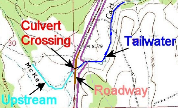
The information for the tailwater is saved in the tailwater arc.
The 'Channel Slope' is determined from the slope of the tailwater arc. The 'Channel Invert Elevation' is initialized with the value of the elevation at upstream end of the tailwater arc.
The 'Channel Type', 'Bottom Width', 'Side Slope', 'Manning's n', 'Constant Tailwater Elevations', 'Irregular Channel Cross-Sections', and 'Rating Curves' are set in the attribute table for the arc.
Roadway Data
The length of the roadway, or 'Crest Length', is determined from the length of the tailwater arc.
The 'Roadway Surface', 'Discharge coefficient', 'Roadway Top Width', and 'Elevation Profile'. The elevation profile will set whether the roadway has a constant roadway elevation or if it is an irregular shape.
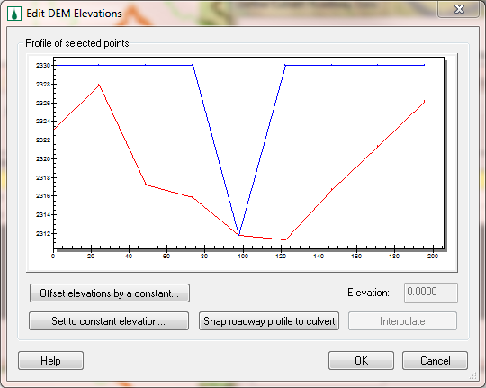
If the user clicks to edit the elevation profile, the user will see a plot with a red line and a blue line. The red line represents the elevation of the DEM while the blue line represents the finished roadway elevation. When the user clicks okay on this dialog, WMS will change the DEM under the roadway arc to match the finished roadway. For this reason, the user must leave one point lower, preferably at the culvert invert elevation, and at the same location as the culvert crossing. When Topaz determines flow directions and accumulations, the water will be able to route through the roadway at the proper location. When WMS brings the roadway profile to HY8, it will remove the lowest point and then remove any points that are unnecessary (if there are three or more points with the same elevation, it will remove all but the points at the end of the group that are the same elevation). HY8 requires that the irregular roadway has between 3 and 15 points. If the profile has 2 points after removing the lowest and unnecessary points, WMS will assign it to be a constant roadway elevation. Otherwise it will assign it to be an irregular roadway profile. If the profile has more than 15 points, WMS will remove the least significant points until it has only 15 points remaining.
Culvert Data
There is no culvert data that is set in WMS. The user must enter all culvert data in the HY-8 interface.
Site Data
Some of the parameters for the site data is saved in the culvert crossing arc and some of the parameters are not changed by WMS.
WMS will take the length of the culvert crossing arc and set the 'Inlet station' to zero and the length to the 'Outlet Station'. The elevations are then set to the elevations of the DEM at those locations of the culvert crossing arc. The 'Number of Barrels' and all of the parameters for the 'Embankment Toe Data' option are not handled by the WMS interface and must be updated in the HY-8 interface.
HY8 Modeling Wizard Steps: Project Filename · Define Project Bounds · Watershed Data · Download Data (Web Service Client) · Read Data (Catalog) · Define Culvert Roadway Data · Compute Flow Directions and Flow Accumulations · Choose Outlet Locations · Delineate Watershed · Select Model · Job Control · Define Land Use and Soil Data · Hydrologic Computations · Define Precipitation · Clean Up Model · Run Hydrologic Model · Crossing Discharge Data · Setup Tailwater Channel · Culvert and Site Data · Run Culvert Analysis · Define Flood Inundation Polygon · Storage Capacity Data · Define Upstream Channel · Delineate Inundated Area
WMS – Watershed Modeling System | ||
|---|---|---|
| Modules: | Terrain Data • Drainage • Map • Hydrologic Modeling • River • GIS • 2D Grid • 2D Scatter |  |
| Models: | CE-QUAL-W2 • GSSHA • HEC-1 • HEC-HMS • HEC-RAS • HSPF • MODRAT • NSS • OC Hydrograph • OC Rational • Rational • River Tools • Storm Drain • SMPDBK • SWMM • TR-20 • TR-55 | |
| Toolbars: | Modules • Macros • Units • Digitize • Static Tools • Dynamic Tools • Drawing • Get Data Tools | |
| Aquaveo | ||


