WMS:Crossing Discharge Data: Difference between revisions
No edit summary |
No edit summary |
||
| Line 1: | Line 1: | ||
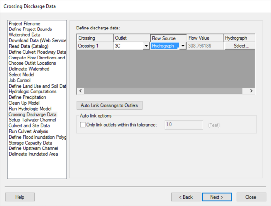
[[Image:HY8ModelingWizardCrossingDischargeData.png|thumb|none|left|550 px|HY8 Modeling Wizard showing the ''Crossing Discharge Data'' step.]] | [[Image:HY8ModelingWizardCrossingDischargeData.png|thumb|none|left|550 px|HY8 Modeling Wizard showing the ''Crossing Discharge Data'' step.]] | ||
The Crossing Discharge Data step allows | The Crossing Discharge Data step allows pulling a hydrograph from the hydrologic simulation, use the peak discharge from the hydrograph, or enter a hydrograph or peak discharge. | ||
== Help == | == Help == | ||
| Line 10: | Line 10: | ||
For more information on how WMS uses this data to set the HY8 Roadway Data, please see: [[WMS:Path_of_Data_from_WMS_To_HY8#Discharge_Data|Path of Data from WMS to HY8]] | For more information on how WMS uses this data to set the HY8 Roadway Data, please see: [[WMS:Path_of_Data_from_WMS_To_HY8#Discharge_Data|Path of Data from WMS to HY8]] | ||
{{WMSHy8ModWizard}} | {{WMSHy8ModWizard}} | ||
Revision as of 15:59, 23 February 2016
The Crossing Discharge Data step allows pulling a hydrograph from the hydrologic simulation, use the peak discharge from the hydrograph, or enter a hydrograph or peak discharge.
Help
We list all the crossings in this dialog. If the “Auto link” option is selected, WMS links the outlets to the culvert crossings if they are within the specified tolerance (the same way outlets are connected to nodes in the storm drain interface).
For each crossing, the flow value and hydrograph are copied to the appropriate fields. Only the flow values on the rising limb of the hydrograph are copied to the XY series--we’re not concerned about the falling limb of the hydrograph since we will only be using the discharge-elevation curve computed by HY-8 for routing the original hydrograph. When WMS runs HY-8, it runs the analysis using the hydrograph peak flow value as the design and maximum flow.
For more information on how WMS uses this data to set the HY8 Roadway Data, please see: Path of Data from WMS to HY8
HY8 Modeling Wizard Steps: Project Filename · Define Project Bounds · Watershed Data · Download Data (Web Service Client) · Read Data (Catalog) · Define Culvert Roadway Data · Compute Flow Directions and Flow Accumulations · Choose Outlet Locations · Delineate Watershed · Select Model · Job Control · Define Land Use and Soil Data · Hydrologic Computations · Define Precipitation · Clean Up Model · Run Hydrologic Model · Crossing Discharge Data · Setup Tailwater Channel · Culvert and Site Data · Run Culvert Analysis · Define Flood Inundation Polygon · Storage Capacity Data · Define Upstream Channel · Delineate Inundated Area
WMS – Watershed Modeling System | ||
|---|---|---|
| Modules: | Terrain Data • Drainage • Map • Hydrologic Modeling • River • GIS • 2D Grid • 2D Scatter |  |
| Models: | CE-QUAL-W2 • GSSHA • HEC-1 • HEC-HMS • HEC-RAS • HSPF • MODRAT • NSS • OC Hydrograph • OC Rational • Rational • River Tools • Storm Drain • SMPDBK • SWMM • TR-20 • TR-55 | |
| Toolbars: | Modules • Macros • Units • Digitize • Static Tools • Dynamic Tools • Drawing • Get Data Tools | |
| Aquaveo | ||
