WMS:Define Flood Inundation Polygon
Overview
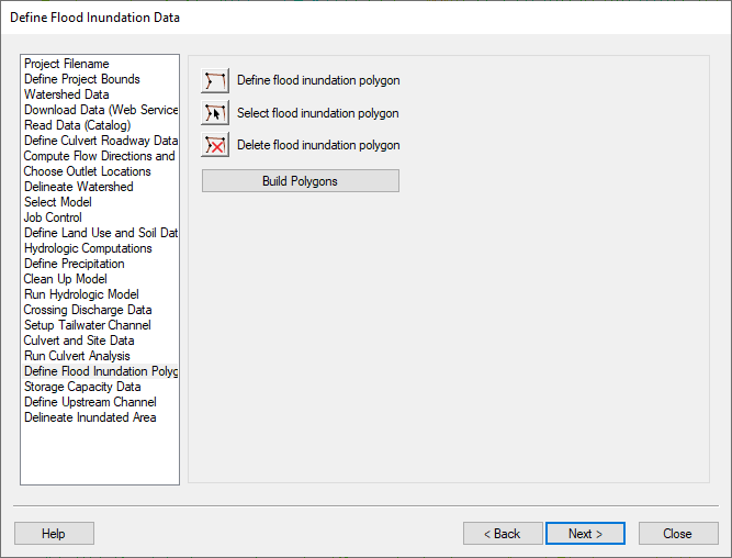
The Define Flood Inundation Polygon step is used to define a flood inundation polygon if a drainage coverage with a polygon defining the inundation area does not already exist. You need to define a flood inundation polygon for any culvert crossings with no outlets (and no basin polygons) assigned but with a hydrograph. The purpose of this inundation polygon is to compute a storage capacity curve and to define a flood barrier when running the floodplain delineation.
Help
Selecting the define flood inundation polygon button allows you to create arcs that represent your flood inundation boundary. Normally, you should use the roadway as one of the arcs and build arcs for the rest of the inundation boundary. If you select delete flood inundation polygon and then click on an arc or inside that polygon, the polygon is deleted and all the generic arcs (not the roadway centerline arcs) making up that polygon are deleted from memory. Selecting build polygons builds all the polygons in the HY-8 coverage and assigns them as flood inundation polygons without prompting whether you want to use all the arcs to build polygons.
HY8 Modeling Wizard Steps: Project Filename · Define Project Bounds · Watershed Data · Download Data (Web Service Client) · Read Data (Catalog) · Define Culvert Roadway Data · Compute Flow Directions and Flow Accumulations · Choose Outlet Locations · Delineate Watershed · Select Model · Job Control · Define Land Use and Soil Data · Hydrologic Computations · Define Precipitation · Clean Up Model · Run Hydrologic Model · Crossing Discharge Data · Setup Tailwater Channel · Culvert and Site Data · Run Culvert Analysis · Define Flood Inundation Polygon · Storage Capacity Data · Define Upstream Channel · Delineate Inundated Area
WMS – Watershed Modeling System | ||
|---|---|---|
| Modules: | Terrain Data • Drainage • Map • Hydrologic Modeling • River • GIS • 2D Grid • 2D Scatter |  |
| Models: | CE-QUAL-W2 • GSSHA • HEC-1 • HEC-HMS • HEC-RAS • HSPF • MODRAT • NSS • OC Hydrograph • OC Rational • Rational • River Tools • Storm Drain • SMPDBK • SWMM • TR-20 • TR-55 | |
| Toolbars: | Modules • Macros • Units • Digitize • Static Tools • Dynamic Tools • Drawing • Get Data Tools | |
| Aquaveo | ||
