WMS:Delineate Watershed: Difference between revisions
No edit summary |
No edit summary |
||
| (13 intermediate revisions by 2 users not shown) | |||
| Line 1: | Line 1: | ||
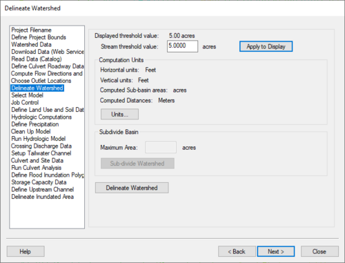
[[Image:WMS Define Watershed. | :[[Image:WMS Define Watershed.png|thumb|none|left|500 px|HY8 Modeling Wizard showing the ''Delineate Watershed'' step]] | ||
The Delineate Watershed step is used to delineate a watershed. | The ''Delineate Watershed'' step is used to delineate a watershed. | ||
== Help == | == Help == | ||
*''Stream threshold value'' – This value is used to modify the stream density. Lower values will cause the streams to be denser while higher values will create fewer streams in the completed model. | |||
*'''Apply to Display''' – Select this button to apply the stream threshold value entered to the display. | |||
*''Create Tc Coverage'' – If this toggle is selected, a Time Computation coverage containing an arc with the longest flow path is created after delineating the watershed and sub-basins. | |||
'''Apply to Display''' – Select this button to apply the stream threshold value entered to the display. | *'''Units...''' – This button is used to define the model and computation coordinates and units. Turn on the option to create a Tc coverage and change which data is computed by selecting the '''Drain Data Compute Opts...''' button in the ''Units'' dialog. | ||
*''Maximum Area'' – Measured in acres. | |||
*'''Sub-divide Watershed''' – This button subdivides the watershed into sub-basins based on the maximum sub-basin area entered. | |||
*'''Delineate Watershed''' – This button delineates the watershed and computes each sub-basin's data based on the selected watershed delineation parameters. | |||
'''Units''' – This button is used to define | |||
'''Sub-divide Watershed''' – This button subdivides | |||
'''Delineate Watershed''' – This button delineates the watershed and computes each sub-basin's data based on the selected watershed delineation parameters. | |||
After delineating a watershed, it is possible to [[WMS:DEM Basins|manually edit the extents of the watershed.]] | After delineating a watershed, it is possible to [[WMS:DEM Basins|manually edit the extents of the watershed.]] | ||
| Line 25: | Line 20: | ||
{{WMSMain}} | {{WMSMain}} | ||
[[Category:WMS To HY8|D]] | [[Category:WMS To HY8|D]] | ||
[[Category:WMS Modeling Wizard Dialog]] | |||
[[Category:WMS Basins|Delineate]] | |||
Latest revision as of 18:05, 15 January 2024
The Delineate Watershed step is used to delineate a watershed.
Help
- Stream threshold value – This value is used to modify the stream density. Lower values will cause the streams to be denser while higher values will create fewer streams in the completed model.
- Apply to Display – Select this button to apply the stream threshold value entered to the display.
- Create Tc Coverage – If this toggle is selected, a Time Computation coverage containing an arc with the longest flow path is created after delineating the watershed and sub-basins.
- Units... – This button is used to define the model and computation coordinates and units. Turn on the option to create a Tc coverage and change which data is computed by selecting the Drain Data Compute Opts... button in the Units dialog.
- Maximum Area – Measured in acres.
- Sub-divide Watershed – This button subdivides the watershed into sub-basins based on the maximum sub-basin area entered.
- Delineate Watershed – This button delineates the watershed and computes each sub-basin's data based on the selected watershed delineation parameters.
After delineating a watershed, it is possible to manually edit the extents of the watershed.
Hydrologic Modeling Wizard Steps: Project Filename · Define Project Bounds · Watershed Data · Download Data (Web Service Client) · Read Data (Catalog) · Compute Flow Directions and Flow Accumulations · Choose Outlet Locations · Delineate Watershed · Select Model · Define and Smooth Streams · Create 2D Grid · Job Control · Define Land Use and Soil Data · Hydrologic Computations · Define Precipitation · Clean Up Model · Run Hydrologic Model
HY8 Modeling Wizard Steps: Project Filename · Define Project Bounds · Watershed Data · Download Data (Web Service Client) · Read Data (Catalog) · Define Culvert Roadway Data · Compute Flow Directions and Flow Accumulations · Choose Outlet Locations · Delineate Watershed · Select Model · Job Control · Define Land Use and Soil Data · Hydrologic Computations · Define Precipitation · Clean Up Model · Run Hydrologic Model · Crossing Discharge Data · Setup Tailwater Channel · Culvert and Site Data · Run Culvert Analysis · Define Flood Inundation Polygon · Storage Capacity Data · Define Upstream Channel · Delineate Inundated Area
WMS – Watershed Modeling System | ||
|---|---|---|
| Modules: | Terrain Data • Drainage • Map • Hydrologic Modeling • River • GIS • 2D Grid • 2D Scatter |  |
| Models: | CE-QUAL-W2 • GSSHA • HEC-1 • HEC-HMS • HEC-RAS • HSPF • MODRAT • NSS • OC Hydrograph • OC Rational • Rational • River Tools • Storm Drain • SMPDBK • SWMM • TR-20 • TR-55 | |
| Toolbars: | Modules • Macros • Units • Digitize • Static Tools • Dynamic Tools • Drawing • Get Data Tools | |
| Aquaveo | ||
