WMS:Hydrologic Computations: Difference between revisions
No edit summary |
No edit summary |
||
| Line 1: | Line 1: | ||
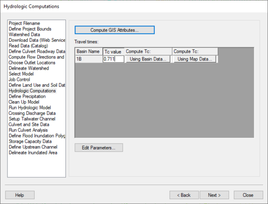
[[Image:HydrologicModelingWizardHydrologicComputations.jpg|thumb|none|left|550 px|HY8 Modeling Wizard showing the ''Hydrologic Computations'' step.]] | [[Image:HydrologicModelingWizardHydrologicComputations.jpg|thumb|none|left|550 px|HY8 Modeling Wizard showing the ''Hydrologic Computations'' step.]] | ||
The Hydrologic Computations step is used to compute hydrologic parameters for | The Hydrologic Computations step is used to compute hydrologic parameters for the watershed and sub-basins. | ||
== Help == | == Help == | ||
'''Compute GIS Attributes''' – Depending on the model | '''Compute GIS Attributes''' – Depending on the model being used, this button brings up a dialog allowing the user to compute attributes from the land use and/or soil type data. | ||
'''Travel times''' – This spreadsheet allows | '''Travel times''' – This spreadsheet allows computing the Time of Concentration for all the sub-basins in the watershed using either the basin data or map data method. | ||
'''Edit Parameters''' – This button brings up the edit parameters dialog for | '''Edit Parameters''' – This button brings up the edit parameters dialog for the model, allowing the user to change modeling parameters for all the sub-basins in the watershed. | ||
{{WMSHydroModWizard}} | {{WMSHydroModWizard}} | ||
Revision as of 16:24, 15 September 2014
The Hydrologic Computations step is used to compute hydrologic parameters for the watershed and sub-basins.
Help
Compute GIS Attributes – Depending on the model being used, this button brings up a dialog allowing the user to compute attributes from the land use and/or soil type data.
Travel times – This spreadsheet allows computing the Time of Concentration for all the sub-basins in the watershed using either the basin data or map data method.
Edit Parameters – This button brings up the edit parameters dialog for the model, allowing the user to change modeling parameters for all the sub-basins in the watershed.
Hydrologic Modeling Wizard Steps: Project Filename · Define Project Bounds · Watershed Data · Download Data (Web Service Client) · Read Data (Catalog) · Compute Flow Directions and Flow Accumulations · Choose Outlet Locations · Delineate Watershed · Select Model · Define and Smooth Streams · Create 2D Grid · Job Control · Define Land Use and Soil Data · Hydrologic Computations · Define Precipitation · Clean Up Model · Run Hydrologic Model
HY8 Modeling Wizard Steps: Project Filename · Define Project Bounds · Watershed Data · Download Data (Web Service Client) · Read Data (Catalog) · Define Culvert Roadway Data · Compute Flow Directions and Flow Accumulations · Choose Outlet Locations · Delineate Watershed · Select Model · Job Control · Define Land Use and Soil Data · Hydrologic Computations · Define Precipitation · Clean Up Model · Run Hydrologic Model · Crossing Discharge Data · Setup Tailwater Channel · Culvert and Site Data · Run Culvert Analysis · Define Flood Inundation Polygon · Storage Capacity Data · Define Upstream Channel · Delineate Inundated Area
WMS – Watershed Modeling System | ||
|---|---|---|
| Modules: | Terrain Data • Drainage • Map • Hydrologic Modeling • River • GIS • 2D Grid • 2D Scatter |  |
| Models: | CE-QUAL-W2 • GSSHA • HEC-1 • HEC-HMS • HEC-RAS • HSPF • MODRAT • NSS • OC Hydrograph • OC Rational • Rational • River Tools • Storm Drain • SMPDBK • SWMM • TR-20 • TR-55 | |
| Toolbars: | Modules • Macros • Units • Digitize • Static Tools • Dynamic Tools • Drawing • Get Data Tools | |
| Aquaveo | ||
