WMS:Compute Flow Directions and Flow Accumulations: Difference between revisions
No edit summary |
No edit summary |
||
| Line 15: | Line 15: | ||
{{WMSMain}} | {{WMSMain}} | ||
[[Category:WMS To HY8|C]] | [[Category:WMS To HY8|C]] | ||
[[Category:WMS Modeling Wizard Dialog]] | |||
{{stub}} | {{stub}} | ||
Revision as of 15:49, 15 December 2015
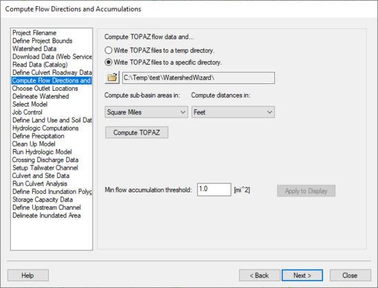
The Compute Flow Directions and Flow Accumulations step is used for running TOPAZ to compute flow directions and accumulations.
Help
Compute TOPAZ flow data and... – Choose either to write the TOPAZ output to a specific directory or to the temp directory. Most frequently, write the TOPAZ output to a temp directory.
Units – Use the units combo boxes to define the model's computation units.
Compute Topaz – This button runs TOPAZ using the selected settings.
Hydrologic Modeling Wizard Steps: Project Filename · Define Project Bounds · Watershed Data · Download Data (Web Service Client) · Read Data (Catalog) · Compute Flow Directions and Flow Accumulations · Choose Outlet Locations · Delineate Watershed · Select Model · Define and Smooth Streams · Create 2D Grid · Job Control · Define Land Use and Soil Data · Hydrologic Computations · Define Precipitation · Clean Up Model · Run Hydrologic Model
HY8 Modeling Wizard Steps: Project Filename · Define Project Bounds · Watershed Data · Download Data (Web Service Client) · Read Data (Catalog) · Define Culvert Roadway Data · Compute Flow Directions and Flow Accumulations · Choose Outlet Locations · Delineate Watershed · Select Model · Job Control · Define Land Use and Soil Data · Hydrologic Computations · Define Precipitation · Clean Up Model · Run Hydrologic Model · Crossing Discharge Data · Setup Tailwater Channel · Culvert and Site Data · Run Culvert Analysis · Define Flood Inundation Polygon · Storage Capacity Data · Define Upstream Channel · Delineate Inundated Area
| [hide] WMS – Watershed Modeling System | ||
|---|---|---|
| Modules: | Terrain Data • Drainage • Map • Hydrologic Modeling • River • GIS • 2D Grid • 2D Scatter |  |
| Models: | CE-QUAL-W2 • GSSHA • HEC-1 • HEC-HMS • HEC-RAS • HSPF • MODRAT • NSS • OC Hydrograph • OC Rational • Rational • River Tools • Storm Drain • SMPDBK • SWMM • TR-20 • TR-55 | |
| Toolbars: | Modules • Macros • Units • Digitize • Static Tools • Dynamic Tools • Drawing • Get Data Tools | |
| Aquaveo | ||
