WMS:Clean Up Model: Difference between revisions
(Redirected page to WMS:Hydrologic Modeling Wizard Overview) |
No edit summary |
||
| (10 intermediate revisions by the same user not shown) | |||
| Line 1: | Line 1: | ||
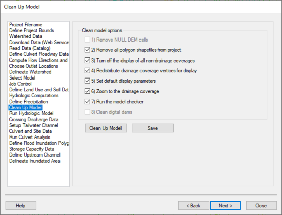
[[Image:HydrologicModelingWizardCleanUpModel.png|thumb|none|left|550 px|HY8 Modeling Wizard showing the ''Clean Up Model'' step.]] | |||
The ''Clean Up Model'' step is used to clean up the model by doing tasks that are typically done when the model is finished. | |||
== Help == | |||
*'''Clean Up Model''' – This button runs only the selected tasks listed above the button. | |||
*'''Save''' – This button saves the project in the current state. | |||
{{WMSHydroModWizard}} | |||
{{WMSHy8ModWizard}} | |||
{{WMSMain}} | |||
[[Category:WMS To HY8|C]] | |||
[[Category:WMS Modeling Wizard Dialog]] | |||
{{stub}} | |||
Latest revision as of 18:06, 15 January 2024
The Clean Up Model step is used to clean up the model by doing tasks that are typically done when the model is finished.
Help
- Clean Up Model – This button runs only the selected tasks listed above the button.
- Save – This button saves the project in the current state.
Hydrologic Modeling Wizard Steps: Project Filename · Define Project Bounds · Watershed Data · Download Data (Web Service Client) · Read Data (Catalog) · Compute Flow Directions and Flow Accumulations · Choose Outlet Locations · Delineate Watershed · Select Model · Define and Smooth Streams · Create 2D Grid · Job Control · Define Land Use and Soil Data · Hydrologic Computations · Define Precipitation · Clean Up Model · Run Hydrologic Model
HY8 Modeling Wizard Steps: Project Filename · Define Project Bounds · Watershed Data · Download Data (Web Service Client) · Read Data (Catalog) · Define Culvert Roadway Data · Compute Flow Directions and Flow Accumulations · Choose Outlet Locations · Delineate Watershed · Select Model · Job Control · Define Land Use and Soil Data · Hydrologic Computations · Define Precipitation · Clean Up Model · Run Hydrologic Model · Crossing Discharge Data · Setup Tailwater Channel · Culvert and Site Data · Run Culvert Analysis · Define Flood Inundation Polygon · Storage Capacity Data · Define Upstream Channel · Delineate Inundated Area
WMS – Watershed Modeling System | ||
|---|---|---|
| Modules: | Terrain Data • Drainage • Map • Hydrologic Modeling • River • GIS • 2D Grid • 2D Scatter |  |
| Models: | CE-QUAL-W2 • GSSHA • HEC-1 • HEC-HMS • HEC-RAS • HSPF • MODRAT • NSS • OC Hydrograph • OC Rational • Rational • River Tools • Storm Drain • SMPDBK • SWMM • TR-20 • TR-55 | |
| Toolbars: | Modules • Macros • Units • Digitize • Static Tools • Dynamic Tools • Drawing • Get Data Tools | |
| Aquaveo | ||
