WMS:Delineate Watershed: Difference between revisions
| Line 1: | Line 1: | ||
== Overview == | == Overview == | ||
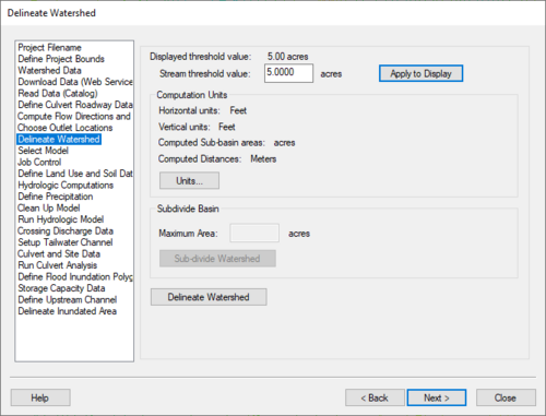
[[Image:WMS Define Watershed.jpg|thumb|none|left|500 px|''Delineate Watershed'' | [[Image:WMS Define Watershed.jpg|thumb|none|left|500 px|HY8 Modeling Wizard showing the ''Delineate Watershed'' step]] | ||
The Delineate Watershed step is used to delineate a watershed. | The Delineate Watershed step is used to delineate a watershed. | ||
Revision as of 14:53, 26 September 2013
Overview
The Delineate Watershed step is used to delineate a watershed.
Help
Stream threshold value – This value is used to modify the stream density. Lower values will cause the streams to be more dense while higher values will create fewer streams in the completed model.
Apply to Display – Select this button to apply the stream threshold value entered to the display.
Create Tc Coverage – If this toggle is selected, a Time Computation coverage containing an arc with the longest flow path is created after delineating the watershed and sub-basins.
Units – This button is used to define your model and computation coordinates and units. You can turn on the option to create a Tc coverage and change which data is computed by selecting the Drain Data Compute Opts... button in the Units dialog.
Sub-divide Watershed – This button subdivides your watershed into sub-basins based on the maximum sub-basin area entered.
Delineate Watershed – This button delineates the watershed and computes each sub-basin's data based on the selected watershed delineation parameters.
After delineating a watershed, it is possible to manually edit the extents of the watershed.
Hydrologic Modeling Wizard Steps: Project Filename · Define Project Bounds · Watershed Data · Download Data (Web Service Client) · Read Data (Catalog) · Compute Flow Directions and Flow Accumulations · Choose Outlet Locations · Delineate Watershed · Select Model · Define and Smooth Streams · Create 2D Grid · Job Control · Define Land Use and Soil Data · Hydrologic Computations · Define Precipitation · Clean Up Model · Run Hydrologic Model
HY8 Modeling Wizard Steps: Project Filename · Define Project Bounds · Watershed Data · Download Data (Web Service Client) · Read Data (Catalog) · Define Culvert Roadway Data · Compute Flow Directions and Flow Accumulations · Choose Outlet Locations · Delineate Watershed · Select Model · Job Control · Define Land Use and Soil Data · Hydrologic Computations · Define Precipitation · Clean Up Model · Run Hydrologic Model · Crossing Discharge Data · Setup Tailwater Channel · Culvert and Site Data · Run Culvert Analysis · Define Flood Inundation Polygon · Storage Capacity Data · Define Upstream Channel · Delineate Inundated Area
WMS – Watershed Modeling System | ||
|---|---|---|
| Modules: | Terrain Data • Drainage • Map • Hydrologic Modeling • River • GIS • 2D Grid • 2D Scatter |  |
| Models: | CE-QUAL-W2 • GSSHA • HEC-1 • HEC-HMS • HEC-RAS • HSPF • MODRAT • NSS • OC Hydrograph • OC Rational • Rational • River Tools • Storm Drain • SMPDBK • SWMM • TR-20 • TR-55 | |
| Toolbars: | Modules • Macros • Units • Digitize • Static Tools • Dynamic Tools • Drawing • Get Data Tools | |
| Aquaveo | ||
