WMS:Define Land Use and Soil Data: Difference between revisions
No edit summary |
(No difference)
|
Revision as of 20:54, 9 February 2011
Overview
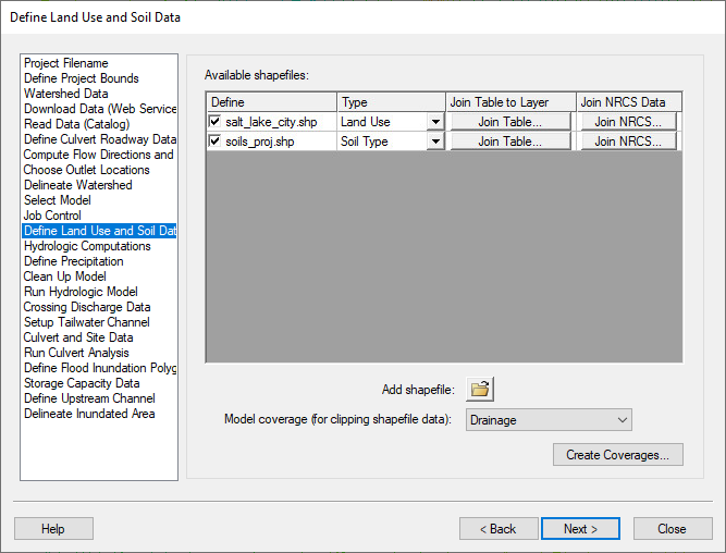
The Define Land Use and Soil Data step converts GIS Module shapefiles to data in the WMS Map module. WMS uses the boundary of your watershed to clip the shapefile data for the selected files.
Help
Create Coverages - Define your land use and soil type shapefiles and a model coverage and your land use/soil data will be transferred to coverages in the map module and clipped to your watershed boundary when you select this button.
Hydrologic Modeling Wizard Steps: Project Filename · Define Project Bounds · Watershed Data · Download Data (Web Service Client) · Read Data (Catalog) · Compute Flow Directions and Flow Accumulations · Choose Outlet Locations · Delineate Watershed · Select Model · Define and Smooth Streams · Create 2D Grid · Job Control · Define Land Use and Soil Data · Hydrologic Computations · Define Precipitation · Clean Up Model · Run Hydrologic Model
HY8 Modeling Wizard Steps: Project Filename · Define Project Bounds · Watershed Data · Download Data (Web Service Client) · Read Data (Catalog) · Define Culvert Roadway Data · Compute Flow Directions and Flow Accumulations · Choose Outlet Locations · Delineate Watershed · Select Model · Job Control · Define Land Use and Soil Data · Hydrologic Computations · Define Precipitation · Clean Up Model · Run Hydrologic Model · Crossing Discharge Data · Setup Tailwater Channel · Culvert and Site Data · Run Culvert Analysis · Define Flood Inundation Polygon · Storage Capacity Data · Define Upstream Channel · Delineate Inundated Area
WMS – Watershed Modeling System | ||
|---|---|---|
| Modules: | Terrain Data • Drainage • Map • Hydrologic Modeling • River • GIS • 2D Grid • 2D Scatter |  |
| Models: | CE-QUAL-W2 • GSSHA • HEC-1 • HEC-HMS • HEC-RAS • HSPF • MODRAT • NSS • OC Hydrograph • OC Rational • Rational • River Tools • Storm Drain • SMPDBK • SWMM • TR-20 • TR-55 | |
| Toolbars: | Modules • Macros • Units • Digitize • Static Tools • Dynamic Tools • Drawing • Get Data Tools | |
| Aquaveo | ||
