WMS:GSSHA Detention Basin Rating Curve: Difference between revisions
From XMS Wiki
Jump to navigationJump to search
(create page) |
No edit summary |
||
| Line 1: | Line 1: | ||
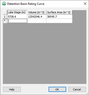
[[File:WMS Detention Basin Rating Curve dialog.png|right|thumb|The ''Detention Basin Rating Curve'' dialog in WMS.]] | [[File:WMS Detention Basin Rating Curve dialog.png|right|thumb|The ''Detention Basin Rating Curve'' dialog in WMS.]] | ||
The ''Detention Basin Rating Curve'' dialog allows for defining a rating curve in a GSSHA detention basin. The data are presented in a spreadsheet format, with one entry per line. It has the following | The ''Detention Basin Rating Curve'' dialog allows for defining a rating curve in a GSSHA detention basin. The data are presented in a spreadsheet format, with one entry per line. It has the following columns: | ||
*''Lake Stage'' – A decimal value in meters for the lake stage. This is the water surface elevation (WSE) for this stage. | *''Lake Stage'' – A decimal value in meters for the lake stage. This is the water surface elevation (WSE) for this stage. | ||
*''Volume'' – The volume of the detention basin in cubic meters. | *''Volume'' – The volume of the detention basin in cubic meters. | ||
*''Surface Area'' – The size of the surface area of the water in the detention basin in square meters. | *''Surface Area'' – The size of the surface area of the water in the detention basin in square meters. | ||
At the bottom of the dialog are the following buttons: | |||
*'''Help''' – Clicking this buttons opens this page in a web browser. | |||
*'''OK''' – Saves any changes made and exits the ''Detention Basin Rating Curve'' dialog. | |||
*'''Cancel''' – Discards any changes made and exits the ''Detention Basin Rating Curve'' dialog. | |||
Revision as of 17:52, 23 April 2019
The Detention Basin Rating Curve dialog allows for defining a rating curve in a GSSHA detention basin. The data are presented in a spreadsheet format, with one entry per line. It has the following columns:
- Lake Stage – A decimal value in meters for the lake stage. This is the water surface elevation (WSE) for this stage.
- Volume – The volume of the detention basin in cubic meters.
- Surface Area – The size of the surface area of the water in the detention basin in square meters.
At the bottom of the dialog are the following buttons:
- Help – Clicking this buttons opens this page in a web browser.
- OK – Saves any changes made and exits the Detention Basin Rating Curve dialog.
- Cancel – Discards any changes made and exits the Detention Basin Rating Curve dialog.
GSSHA | |
|---|---|
| XMS Wiki Links | Calibration (Automated • Manual • Output) • Channel Routing • Contaminants • Digital Dams • Embankment Arcs • Feature Objects (Arcs • Nodes • Polygons) • File Types • Groundwater • Groups • Hydraulic Structures • Job Control • Join SSURGO Data • Mapping Tables • Maps • Menu • Model Linkage • Multiple Simulations • Nutrients • Observations • Output Control • Overland Soil Erosion • Pipe and Node Parameters • Precipitation • Radar Rainfall • Save GSSHA Project File • Smooth GSSHA Streams • Snowmelt • Solution (Analysis • Data) |
| Related Tools | MWBM Wizard • Using Soil Type Data with GSSHA |
| GSSHA Wiki External Links | GSSHA Wiki: Overview • Primer • User's Manual • Tutorials |
WMS – Watershed Modeling System | ||
|---|---|---|
| Modules: | Terrain Data • Drainage • Map • Hydrologic Modeling • River • GIS • 2D Grid • 2D Scatter |  |
| Models: | CE-QUAL-W2 • GSSHA • HEC-1 • HEC-HMS • HEC-RAS • HSPF • MODRAT • NSS • OC Hydrograph • OC Rational • Rational • River Tools • Storm Drain • SMPDBK • SWMM • TR-20 • TR-55 | |
| Toolbars: | Modules • Macros • Units • Digitize • Static Tools • Dynamic Tools • Drawing • Get Data Tools | |
| Aquaveo | ||
