WMS:GSSHA Precipitation: Difference between revisions
No edit summary |
|||
| Line 14: | Line 14: | ||
*''Duration'' – Rainfall duration as an integer in minutes. | *''Duration'' – Rainfall duration as an integer in minutes. | ||
*''Start date/time'' – A date and time drop-down that allows for selecting the start time of the rainfall event. Selection can be made directly from the drop-down, or the following information can be entered in "MM/DD/YYYY H:MN:SS AM/PM" format: | *''Start date/time'' – A date and time drop-down that allows for selecting the start time of the rainfall event. Selection can be made directly from the drop-down, or the following information can be entered in "MM/DD/YYYY H:MN:SS AM/PM" format: | ||
**''MM'' – Month. | **''MM'' – Month. It can be either one or two digits. | ||
**''DD'' – Day, entered in two-digit format ("04" for the fourth day of the month). | **''DD'' – Day, entered in a two-digit format ("04" for the fourth day of the month). | ||
**''YYYY'' &ndash Year, entered in four-digit format. | **''YYYY'' &ndash Year, entered in four-digit format. | ||
**''H'' – Hour, can be either one or two digits. | **''H'' – Hour, can be either one or two digits. | ||
**''MN'' – Minutes, entered in two-digit format. | **''MN'' – Minutes, entered in a two-digit format. | ||
**''SS'' – Seconds, entered in two-digit format. | **''SS'' – Seconds, entered in a two-digit format. | ||
**''AM/PM'' – Enter either "AM" or "PM". | **''AM/PM'' – Enter either "AM" or "PM". | ||
Revision as of 21:12, 23 March 2020
The GSSHA Precipitation dialog can be accessed by selecting GSSHA | Precipitation... while in the 2D Grid ![]() module. All rainfall types in GSSHA must be tied to a specific point in time by specifying the year, month, day, hour, and minute of each rainfall data point. This dialog allows specifying the type of rainfall and entering the necessary data associated with the rainfall type.
module. All rainfall types in GSSHA must be tied to a specific point in time by specifying the year, month, day, hour, and minute of each rainfall data point. This dialog allows specifying the type of rainfall and entering the necessary data associated with the rainfall type.
Rainfall can be input in one of the following formats, selected from the drop-down in the Rainfall event(s) section:
- "Uniform"
- "Gage"
- "Hyetograph"
- "Nexrad Radar"
Uniform
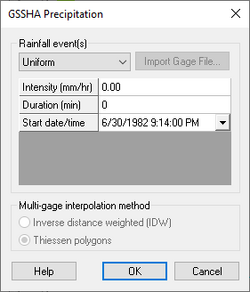
The ability to assign uniform rainfall over the entire watershed is maintained largely as a trouble-shooting feature and is mostly used in initial model development. Real watersheds are modeled with temporally- and spatially-varying rainfall. When "Uniform" is selected from the Rainfall event(s) drop-down, the following rows appear in the spreadsheet:
- Intensity – Rainfall intensity as a decimal value in millimeters per hour.
- Duration – Rainfall duration as an integer in minutes.
- Start date/time – A date and time drop-down that allows for selecting the start time of the rainfall event. Selection can be made directly from the drop-down, or the following information can be entered in "MM/DD/YYYY H:MN:SS AM/PM" format:
- MM – Month. It can be either one or two digits.
- DD – Day, entered in a two-digit format ("04" for the fourth day of the month).
- YYYY &ndash Year, entered in four-digit format.
- H – Hour, can be either one or two digits.
- MN – Minutes, entered in a two-digit format.
- SS – Seconds, entered in a two-digit format.
- AM/PM – Enter either "AM" or "PM".
This option disables the Multi-gage interpolation method section.
Gage
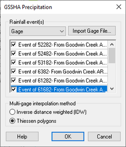
Select the "Gage" option to specify single or multi-gage rainfall. Rainfall distributions for all rain gages should already be entered on a rain gage coverage in WMS. Create a separate rain gage coverage for each precipitation event. Rain gage files constructed using an editor outside of WMS can be used in two ways:
- Reference the file in the Manage Files dialog when saving the GSSHA project file, or
- Use the Import Gage File... button to import the file and generate rain gage coverages in WMS.
The spreadsheet lists all the individual storm event coverages. Each one can be turned on or off as needed, depending on whether the coverage has a single gage or multiple gages.
Temporally Varying, Spatially Uniform (Single Gage) Rainfall
Single-gage rainfall produces a time series of rainfall for the entire watershed. Toggle on the the rain gage coverages (containing a single gage) in the dialog that will be used for writing the GAG file required by GSSHA.
Temporally Varying Multiple-Gage Rainfall
Select rain gage coverages with multiple gages defined to be used for writing the GAG file required by GSSHA. Specify in the Multi-gage interpolation method section whether to use Inverse distance weighting (IDW) or Thiessen polygons for determining the spatial variation in rainfall for each grid cell.
Hyetograph
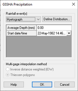
Select the "Hyetograph" option to enter a temporally varying, spatially uniform (single-gage) event without creating a rain gage coverage. Click Define Distribution... button to open the XY Series Editor dialog in order to define the temporal distribution.
The spreadsheet has the following rows:
- Average Depth – A decimal depth value in millimeters.
- Start date/time – A date and time drop-down that allows for selecting the start time of the rainfall event. Selection can be made directly from the drop-down, or the following information can be entered in "MM/DD/YYYY H:MN:SS AM/PM" format:
- MM – Month. Can be either one or two digits.
- DD – Day, entered in two-digit format ("04" for the fourth day of the month).
- YYYY &ndash Year, entered in four digit format.
- H – Hour, can be either one or two digits.
- MN – Minutes, entered in two digit format.
- SS – Seconds, entered in two digit format.
- AM/PM – Enter either "AM" or "PM".
This option disables the Multi-gage interpolation method section.
Nexrad Radar
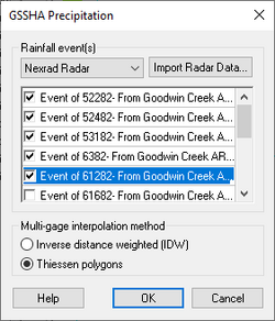
Select the "Nexrad Radar" option and click Import Radar Data... to bring up the Convert Grids dialog to import downloaded NEXRAD rainfall data for use in GSSHA. WMS will output the GSSHA rainfall (GAG) file using the "RADAR" type.
The spreadsheet lists all the individual storm event coverages. Each one can be turned on or off as needed, depending on whether the coverage has a single gage or multiple gages.
For "RADAR" type rainfall inputs, "Thiessen polygons" should be selected in theMulti-gage interpolation method section. This option is selected by default.
See Also
GSSHA | |
|---|---|
| XMS Wiki Links | Calibration (Automated • Manual • Output) • Channel Routing • Contaminants • Digital Dams • Embankment Arcs • Feature Objects (Arcs • Nodes • Polygons) • File Types • Groundwater • Groups • Hydraulic Structures • Job Control • Join SSURGO Data • Mapping Tables • Maps • Menu • Model Linkage • Multiple Simulations • Nutrients • Observations • Output Control • Overland Soil Erosion • Pipe and Node Parameters • Precipitation • Radar Rainfall • Save GSSHA Project File • Smooth GSSHA Streams • Snowmelt • Solution (Analysis • Data) |
| Related Tools | MWBM Wizard • Using Soil Type Data with GSSHA |
| GSSHA Wiki External Links | GSSHA Wiki: Overview • Primer • User's Manual • Tutorials |
WMS – Watershed Modeling System | ||
|---|---|---|
| Modules: | Terrain Data • Drainage • Map • Hydrologic Modeling • River • GIS • 2D Grid • 2D Scatter |  |
| Models: | CE-QUAL-W2 • GSSHA • HEC-1 • HEC-HMS • HEC-RAS • HSPF • MODRAT • NSS • OC Hydrograph • OC Rational • Rational • River Tools • Storm Drain • SMPDBK • SWMM • TR-20 • TR-55 | |
| Toolbars: | Modules • Macros • Units • Digitize • Static Tools • Dynamic Tools • Drawing • Get Data Tools | |
| Aquaveo | ||


