WMS:GSSHA Manage Files: Difference between revisions
No edit summary |
(rm related in template) |
||
| Line 9: | Line 9: | ||
{{GSSHA Wiki}} | |||
{{WMSMain}} | {{WMSMain}} | ||
[[Category:GSSHA|M]] | [[Category:GSSHA|M]] | ||
[[Category:GSSHA Dialogs|Man]] | [[Category:GSSHA Dialogs|Man]] | ||
Revision as of 20:44, 22 March 2019
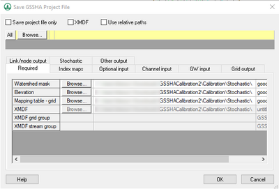
The Save GSSHA Project File editor can be accessed from the GSSHA Job Control options. In the GSSHA Job Control Parameters dialog, turn on the spreadsheet option to Manage files and select Edit parameters to bring up the GSSHA Project File editor. This option is not normally used if setting up a basic GSSHA model or if new to the GSSHA model.
There are several files that are included as a part of the GSSHA project. If building a basic GSSHA model using the WMS interface, the individual file names associated with the GSSHA project are not normally edited. However, there might be a need to rename a specific index map, other project file, or one of the files saved from WMS. Use the GSSHA Project File editor to rename one of the files in the GSSHA project to a different name.
Fields in the GSSHA Project File editor are turned off or on depending on whether certain features are turned off or on in the GSSHA interface. For example, if the option to output infiltration depth is turned off in the output control, the name of the infiltration depth file name cannot be edited. Turn on the option to export the infiltration depth from GSSHA to define an infiltration depth filename in the GSSHA Project File editor.
There is also a Save project file only option at the top of the dialog to only save a GSSHA project file with all of the names specified in the GSSHA Project File dialog.
GSSHA | |
|---|---|
| XMS Wiki Links | Calibration (Automated • Manual • Output) • Channel Routing • Contaminants • Digital Dams • Embankment Arcs • Feature Objects (Arcs • Nodes • Polygons) • File Types • Groundwater • Groups • Hydraulic Structures • Job Control • Join SSURGO Data • Mapping Tables • Maps • Menu • Model Linkage • Multiple Simulations • Nutrients • Observations • Output Control • Overland Soil Erosion • Pipe and Node Parameters • Precipitation • Radar Rainfall • Save GSSHA Project File • Smooth GSSHA Streams • Snowmelt • Solution (Analysis • Data) |
| Related Tools | MWBM Wizard • Using Soil Type Data with GSSHA |
| GSSHA Wiki External Links | GSSHA Wiki: Overview • Primer • User's Manual • Tutorials |
WMS – Watershed Modeling System | ||
|---|---|---|
| Modules: | Terrain Data • Drainage • Map • Hydrologic Modeling • River • GIS • 2D Grid • 2D Scatter |  |
| Models: | CE-QUAL-W2 • GSSHA • HEC-1 • HEC-HMS • HEC-RAS • HSPF • MODRAT • NSS • OC Hydrograph • OC Rational • Rational • River Tools • Storm Drain • SMPDBK • SWMM • TR-20 • TR-55 | |
| Toolbars: | Modules • Macros • Units • Digitize • Static Tools • Dynamic Tools • Drawing • Get Data Tools | |
| Aquaveo | ||
