WMS:GSSHA
Gridded Surface Subsurface Hydrologic Analysis (GSSHA) is a two-dimensional finite difference rainfall/runoff model. A finite difference grid is used to establish the computational domain and parameters for surface runoff. The GSSHA model is fully coupled with hydraulic stream flow/routing models. Parameters for stream channels are defined using arcs and then mapped to the appropriate underlying grid cells.
Features of GSSHA include 1D stream flow and infiltration, 2D overland flow and groundwater, and full coupling between the groundwater, shallow soils, streams, and overland flow.[1] "Sediment and constituent fate and transport are simulated in the shallow soils, overland flow plane, and in streams and channels. GSSHA can be used as an episodic or continuous model where soil surface moisture, groundwater levels, stream interactions, and constituent fate are continuously simulated. The fully coupled groundwater to surface-water interaction allows GSSHA to model basins in both arid and humid environments."[1]
The GSSHA model can be added to a paid edition of WMS.[2]
GSSHA Menus
There are two GSSHA menus in WMS:
- When in the Map
 module, the GSSHA menu is available when a GSSHA coverage is selected. See here for more details.
 - When in the 2D Grid
 module, the main GSSHA menu is available. See here for more details.
Cell Properties
The 2D grid cell properties include an I,J location and a scalar or index map value. The scalar or index map value is associated with the currently selected dataset in the Project Explorer and can be edited in the Properties Window. The I,J location can be viewed but not edited in the Properties Window. The 2D grid contours are a way of visualizing the spatial variation of the scalar or index map values for the selected dataset.
Model Check
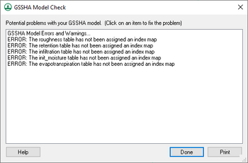
The GSSHA Model Check dialog lists potential problems with the GSSHA model. Clicking on a specific warning or error will open a dialog that will allow the potential problem to be fixed, if needed.
At the bottom of the dialog are three buttons:
- Help – Opens this article in a web browser.
- Done – Closes the GSSHA Model Check dialog.
- Print – Opens a Choose name of output file dialog. Enter the desired File name and click Save to export the model check information to a text file.
References
- ^ a b "Overview:Overview". GSSHA Wiki. http://www.gsshawiki.com/Overview:Overview. Retrieved on April 26, 2019.
- ^ "WMS Editions & Pricing". Aquaveo. http://www.aquaveo.com/software/wms-pricing. Retrieved on April 26, 2019.
GSSHA | |
|---|---|
| XMS Wiki Links | Calibration (Automated • Manual • Output) • Channel Routing • Contaminants • Digital Dams • Embankment Arcs • Feature Objects (Arcs • Nodes • Polygons) • File Types • Groundwater • Groups • Hydraulic Structures • Job Control • Join SSURGO Data • Mapping Tables • Maps • Menu • Model Linkage • Multiple Simulations • Nutrients • Observations • Output Control • Overland Soil Erosion • Pipe and Node Parameters • Precipitation • Radar Rainfall • Save GSSHA Project File • Smooth GSSHA Streams • Snowmelt • Solution (Analysis • Data) |
| Related Tools | MWBM Wizard • Using Soil Type Data with GSSHA |
| GSSHA Wiki External Links | GSSHA Wiki: Overview • Primer • User's Manual • Tutorials |
WMS – Watershed Modeling System | ||
|---|---|---|
| Modules: | Terrain Data • Drainage • Map • Hydrologic Modeling • River • GIS • 2D Grid • 2D Scatter |  |
| Models: | CE-QUAL-W2 • GSSHA • HEC-1 • HEC-HMS • HEC-RAS • HSPF • MODRAT • NSS • OC Hydrograph • OC Rational • Rational • River Tools • Storm Drain • SMPDBK • SWMM • TR-20 • TR-55 | |
| Toolbars: | Modules • Macros • Units • Digitize • Static Tools • Dynamic Tools • Drawing • Get Data Tools | |
| Aquaveo | ||
