WMS:GSSHA Snowmelt Options
From XMS Wiki
(Redirected from WMS:GSSHA Snowmelt Options Dialog)
Jump to navigationJump to search
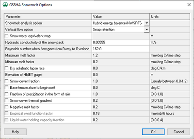
The GSSHA Snowmelt Options dialog contains options for how GSSHA handles various aspects of snowmelt within the simulation. The dialog consists of three columns: Parameters, Value, and Units.
The Help button at the bottom of the dialog opens this page in a web browser.
The options are as follows:
- Snowmelt analysis option – A drop-down list with the following options:
- "Hybrid energy balance/NWSRFS" – A hybrid method based on both of the other two options.
- "Energy balance" – A simple method where the amount of heat available is applied to the snowpack and the amount of meltwater is calculated. See the GSSHA Wiki for more details.
- "Temperature index method" – A method of estimating snowfall accumulation and melting based on the National Weather Service River Forecasting System (NWSRFS) SNOW-17 model. See the GSSHA Wiki for more details. Selecting this option turns on Empirical wind function factor and Liquid water holding capacity fraction at the bottom of the dialog.
- Vertical flow options – A drop-down list with the following options:
- "Snap retention" – Uses the SNAP gravity flow model to distribute melt-water vertically through the snow pack and to the overland.
- "Vertical snow retention" – GSSHA creates multiple melt-waves (up to 6 simultaneous waves) that distribute the melt to the overland.
- Snow water equivalent map – Turn on this option to activate a drop-down list of all continuous maps in the project.
- Hydraulic conductivity of the snow pack – A decimal value in meters per second.
- Reynolds number when flow goes from Darcy to Overland – A unitless decimal value.
- Maximum melt factor – A decimal value in millimeters per degree Celsius per time step.
- Minimum melt factor – A decimal value in millimeters per degree Celsius per time step.
- Dry adiabetic lapse rate – Turn on this option to activate editability of this decimal value in degrees Celsius per kilometer. Also activates editability of Elevation of HMET gage (below).
- Elevation of HMET gage – A decimal value in meters.
- Snow cover fraction – A decimal value usually between "0.8" and "1.2".
- Base temperature to begin melt – A decimal temperature value in degrees Celsius.
- Fraction of precipitation in the form of rain – A decimal percentage value between "0.0" and "1.0".
- Snow cover thermal gradient – A decimal percentage value between "0.0" and "1.0".
- Negative melt factor – A decimal value in millimeters per degree Celsius per time step.
- Empirical wind function factor – A decimal value in millimeters per millibars per 6 hours.
- Liquid water holding capacity fraction – A decimal value between "0.0" and "0.4".
GSSHA | |
|---|---|
| XMS Wiki Links | Calibration (Automated • Manual • Output) • Channel Routing • Contaminants • Digital Dams • Embankment Arcs • Feature Objects (Arcs • Nodes • Polygons) • File Types • Groundwater • Groups • Hydraulic Structures • Job Control • Join SSURGO Data • Mapping Tables • Maps • Menu • Model Linkage • Multiple Simulations • Nutrients • Observations • Output Control • Overland Soil Erosion • Pipe and Node Parameters • Precipitation • Radar Rainfall • Save GSSHA Project File • Smooth GSSHA Streams • Snowmelt • Solution (Analysis • Data) |
| Related Tools | MWBM Wizard • Using Soil Type Data with GSSHA |
| GSSHA Wiki External Links | GSSHA Wiki: Overview • Primer • User's Manual • Tutorials |
WMS – Watershed Modeling System | ||
|---|---|---|
| Modules: | Terrain Data • Drainage • Map • Hydrologic Modeling • River • GIS • 2D Grid • 2D Scatter |  |
| Models: | CE-QUAL-W2 • GSSHA • HEC-1 • HEC-HMS • HEC-RAS • HSPF • MODRAT • NSS • OC Hydrograph • OC Rational • Rational • River Tools • Storm Drain • SMPDBK • SWMM • TR-20 • TR-55 | |
| Toolbars: | Modules • Macros • Units • Digitize • Static Tools • Dynamic Tools • Drawing • Get Data Tools | |
| Aquaveo | ||
