WMS:GSSHA Storm Drain: Difference between revisions
No edit summary |
No edit summary |
||
| (2 intermediate revisions by the same user not shown) | |||
| Line 1: | Line 1: | ||
The "GSSHA Storm Drain" coverage in WMS is used to hold feature arcs, nodes, and polygons related to subsurface drainage | {{TOC right}}The "GSSHA Storm Drain" coverage in WMS is used to hold feature arcs, nodes, and polygons related to subsurface drainage networks or agricultural tile drain models. | ||
==GSSHA Storm Drain Coverage== | |||
Beginning with WMS 10.0, '''pipe''' arc types are defined in a "GSSHA Storm Drain" coverage. This makes it so pipes drawn inside of WMS do not impact stream elevations in the "GSSHA" coverage. | |||
[[File:WMS Project Explorer showing GSSHA and GSSHA Storm Drain coverages.png|thumb|none|left|200 px|The "GSSHA Storm Drain" coverage has been separated from the GSSHA Coverage]] | |||
When importing an existing GSSHA project with pipe arcs in a "GSSHA" coverage, WMS automatically converts the pipe arcs to generic arcs in the "GSSHA" coverage and copies the pipes into a new "GSSHA Storm Drain" coverage. Existing files with a "GSSHA Storm Drain" coverage can be imported, edited, and run in GSSHA from the WMS interface. The generic arcs that were pipes and were left in the "GSSHA" coverage can be deleted if desired. | |||
Creating a "GSSHA Storm Drain" coverage uses the same steps as [[WMS:Coverages|creating any other coverage]], including [[WMS:Coverages#Coverage Types|setting the type]] to "GSSHA Storm Drain". | |||
==Pipe Junction== | ==Pipe Junction== | ||
| Line 11: | Line 20: | ||
;Manhole Area | ;Manhole Area | ||
:Enter the manhole area | :Enter the manhole area in m<sup>2</sup>. | ||
;Inlet Type | ;Inlet Type | ||
Latest revision as of 21:47, 21 May 2019
The "GSSHA Storm Drain" coverage in WMS is used to hold feature arcs, nodes, and polygons related to subsurface drainage networks or agricultural tile drain models.
GSSHA Storm Drain Coverage
Beginning with WMS 10.0, pipe arc types are defined in a "GSSHA Storm Drain" coverage. This makes it so pipes drawn inside of WMS do not impact stream elevations in the "GSSHA" coverage.
When importing an existing GSSHA project with pipe arcs in a "GSSHA" coverage, WMS automatically converts the pipe arcs to generic arcs in the "GSSHA" coverage and copies the pipes into a new "GSSHA Storm Drain" coverage. Existing files with a "GSSHA Storm Drain" coverage can be imported, edited, and run in GSSHA from the WMS interface. The generic arcs that were pipes and were left in the "GSSHA" coverage can be deleted if desired.
Creating a "GSSHA Storm Drain" coverage uses the same steps as creating any other coverage, including setting the type to "GSSHA Storm Drain".
Pipe Junction
The following data required for modeling storm/tile drain systems is entered at pipe junction nodes.
- Super Junction Number
- The super junction number is computed by WMS by using the GSSHA | Number Storm Drain menu command in the 2D Grid
 module, but can also be manually edited at any time.
- Invert Elevation
- Enter the invert elevation in meters of the pipe at this location.
- Manhole Area
- Enter the manhole area in m2.
- Inlet Type
- The inlet type is used to account for flow into or out of the pipe network. Select 0-9 grate inlets to specify the amount of flow into the pipe network. Choose Empty to grid cell or Empty to channel to indicate that flow from the pipe network will be routed either back to the grid cell or into the 1D stream network.
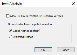
Storm/Tile Drain Dialog
The GSSHA Storm/tile drain dialog is accessible by clicking the Edit parameters... button to the right of Storm/tile drain in the list of other parameters in the GSSHA Job Control Parameters dialog. It has three options:
- Allow GSSHA to redistribute Superlink Vertices – Turn on to allow GSSHA to redistribute superlink vertices.
- Groundwater flow computation method section
References
- ^ Cooke, Richard A.; Badiger, Shrinivas M.; García, Ana Maria (June 21, 2001). "Drainage equations for random and irregular tile drainage systems". Agricultural Water Management 48 (3): 207-224. Archived from the original on April 30, 2019. https://www.sciencedirect.com/science/article/pii/S0378377400001360.
- ^ Skaggs, R.W. (1980). DRAINMOD Reference Report - Methods for design and evaluation of drainage-water management systems for soils with high water tables. Texas: USDA SCS, South National Technical Center.
GSSHA | |
|---|---|
| XMS Wiki Links | Calibration (Automated • Manual • Output) • Channel Routing • Contaminants • Digital Dams • Embankment Arcs • Feature Objects (Arcs • Nodes • Polygons) • File Types • Groundwater • Groups • Hydraulic Structures • Job Control • Join SSURGO Data • Mapping Tables • Maps • Menu • Model Linkage • Multiple Simulations • Nutrients • Observations • Output Control • Overland Soil Erosion • Pipe and Node Parameters • Precipitation • Radar Rainfall • Save GSSHA Project File • Smooth GSSHA Streams • Snowmelt • Solution (Analysis • Data) |
| Related Tools | MWBM Wizard • Using Soil Type Data with GSSHA |
| GSSHA Wiki External Links | GSSHA Wiki: Overview • Primer • User's Manual • Tutorials |
WMS – Watershed Modeling System | ||
|---|---|---|
| Modules: | Terrain Data • Drainage • Map • Hydrologic Modeling • River • GIS • 2D Grid • 2D Scatter |  |
| Models: | CE-QUAL-W2 • GSSHA • HEC-1 • HEC-HMS • HEC-RAS • HSPF • MODRAT • NSS • OC Hydrograph • OC Rational • Rational • River Tools • Storm Drain • SMPDBK • SWMM • TR-20 • TR-55 | |
| Toolbars: | Modules • Macros • Units • Digitize • Static Tools • Dynamic Tools • Drawing • Get Data Tools | |
| Aquaveo | ||

